Category: News

  • A Mexican cave wall looked blank to the eye. Three glyphs were hiding on it, and one of them is a place name that should not have been there

    A Mexican cave wall looked blank to the eye. Three glyphs were hiding on it, and one of them is a place name that should not have been there

    The cave is small, high on a hill in the Mexican state of Morelos, and the back of it narrows to a low bedrock shelf about 1.45 metres wide and half a metre deep. If you crouched there with a torch you would see a wall, a shelf, and a smear of soot. Christophe Helmke photographed that wall, took the photographs home to Copenhagen, and pulled three painted figures out of them that are effectively invisible to the naked eye.

    One of those three is a mountain with scrolls curling out of its sides. The scrolls, in the visual grammar of ancient central Mexico, mean sound. Speech, or song. Helmke and his co-authors read the sign as a place name, the Singing Mountain, and the reason that matters is that the same place name turns up painted on a wall in the murals of Teotihuacan, more than a hundred kilometres away, in the compound known as Tetitla.

    That is the whole claim in one sentence, and it is a bigger claim than it sounds, because it is not really about a cave. It is about whether the largest city in the ancient Americas could write.

    The paper was published online in Antiquity in late September 2026, under the title Painted Teotihuacan glyphs of Cave 19, Chalcatzingo, Morelos, Mexico. The author list runs Christophe Helmke and Jesper Nielsen, both of the University of Copenhagen, with Carolina Meza Rodriguez and Mario Cordova Tello of Mexico’s Instituto Nacional de Antropologia e Historia. That last detail is worth holding on to. Chalcatzingo is a site under Mexican national stewardship, the INAH names are not decorative, and the work is a joint reading, not a foreign scholar’s announcement about somebody else’s hill.

    Chalcatzingo is one of the famous places in Mesoamerican archaeology, and famous for something else entirely. It sits in a saddle between two hills, the Cerro Chalcatzingo and the narrower Cerro Delgado, and it is best known for monumental carved reliefs of the Olmec horizon, roughly a thousand years before the period in question here. Generations of archaeologists have walked that site. Cave 19, on the western face of the Cerro Delgado, was known and recorded. The paint was there the whole time. It had simply faded past the point where a human eye could resolve it into anything.

    It is worth being clear about why a cave at all. Caves in central Mexican thought were not incidental features of landscape. They were openings, entrances to something, and the hills that contained them were themselves actors in the religious geography rather than scenery. Teotihuacan itself was built over a tunnel. Later Nahua tradition traces origins to a place of caves. A painted panel in a small opening on the side of a hill, with evidence of burning under it, fits a pattern of behaviour that is documented across the region and across centuries, and that pattern is part of why the authors read glyph 3 as ceremonial rather than ornamental.

    The Cerro Delgado is also not a convenient destination. It is the narrower of the two hills at Chalcatzingo, and Cave 19 sits on its western face, which means getting to it, surveying it, and photographing a wall in a cramped recess with controlled enough light to be processed afterwards. None of that is glamorous and all of it is the reason the paper exists. The plan published with it, drawn and surveyed by Helmke, is the sort of document that takes a day of discomfort to produce and five seconds to look at.

    What changed was the processing. The pigment is a dark red, carrying hematite, and what survives of it is thin and patchy against a stained limestone wall. Helmke ran the photographs through two different kinds of enhancement and published the results side by side. One route is ordinary image software used unusually carefully: isolating the alpha channel in Adobe Photoshop, then setting lightness and alpha channels against each other so that a faint colour difference the eye reads as noise becomes a hard edge. The other route is DStretch, a decorrelation stretch tool built specifically for rock art, which takes the colour information in an image and exaggerates the directions in which it actually varies. DStretch outputs are false colour by design. They look like something off a thermal camera. The paper publishes four separate colourspaces for the first glyph alone, with names like LAB-based Red Enhance and YUV-based BlacK, and the point of publishing four is that a reader can check whether a shape survives all of them or only appears in one.

    That is the honest methodological core of this, and it is why the figures in the paper look so strange. The team is not showing you a painting. It is showing you the evidence that a painting is still faintly present, four different ways, and then a line drawing of what they believe it is.

    So what are the three?

    Glyph 1 is the mountain. In the reading offered, it is a tri-mountain sign, a convention for high ground, with lateral scrolls for speech or song attached to it. The authors propose it reads as Singing Mountain, and connect it to the Nahuatl place name Cuicatepec, which carries the same meaning in a language documented centuries later. If that link holds, it implies a naming practice for this particular landform that survived from the Classic period into the early colonial era, which is a long time for a name to stay attached to a hill.

    Glyph 2 is a cluster of three elements: a beaded necklace, a segment of cloth, and an upright dart of the kind thrown with an atlatl. Earlier scholarship has sometimes read assemblages like this as funerary bundles. Helmke and colleagues argue instead that it is warrior attire functioning as a title, a way of writing a particular martial rank rather than depicting a dead man’s possessions.

    Glyph 3 is the one sitting right by the soot. It is a large rectangular frame filled with five-pointed stars, and it occupies the wall above that low bedrock shelf. Part of the back wall and the ceiling over the shelf is blackened by what the paper calls fire-clouding, the dark staining left by repeated burning in a confined space. The authors argue the starry frame represents a type of arched awning, a structure that appears in Teotihuacan imagery on elaborate incense burners, the so-called theatre-style censers, and on painted and incised vessels, in contexts associated with ceremonies for dead warriors.

    Put the three together and you get the shape of an argument rather than a certainty: a place name, a warrior title, and a ritual structure, painted in a cave where something was repeatedly burned, in a visual language belonging to a city a long walk away.

    The fire matters more than it first appears. A painted panel on its own is decoration, and decoration can be idle. A painted panel directly above a shelf with soot on the wall and ceiling above it is a panel attached to an activity. The authors read that as a pyrolytic ritual, which is a careful way of saying burning was done here on purpose, more than once, in the immediate presence of these marks. They raise cremation as a possibility. They do not claim to have found human remains, and the piece should not be read as though they did.

    Now the part that makes this an argument instead of a curiosity.

    Mesoamerica has writing systems that nobody disputes. Maya script is read today with real fluency, kings and dates and dynastic quarrels and all. Aztec writing, later and working differently, is also accepted as writing. Teotihuacan has always been the awkward one. It was enormous, it was influential across a huge area, its art is covered in repeated signs, and for decades the mainstream position was that those signs were emblems: identity markers, insignia, labels, notation of a kind, but not a script encoding a language that someone could read aloud.

    Helmke is not a neutral party to that dispute, and the piece is better for saying so. In 2025, a year before the cave paper, he published in Current Anthropology with the linguist Magnus Pharao Hansen under the title The Language of Teotihuacan Writing, arguing not only that Teotihuacan notation is writing but that it encoded a specific language, a Uto-Aztecan tongue ancestral to Nahuatl, Cora and Huichol. That paper lays out principles it says Teotihuacan shared with other Mesoamerican traditions, including logograms used on the rebus principle, and proposes new readings of several signs. The Antiquity cave paper sits inside that programme. It describes a logo-phonetic script with something in the order of 120 distinct graphemes, and frames the Cave 19 material as adding to a growing corpus and broadening the understood reach of the system in time and space.

    Which is exactly why the number three should stay in front of the reader.

    Three glyphs is three glyphs. The paper is an interpretation of three faded painted figures, offered by scholars who have a stated position on the larger question and who are honest in print about what they are arguing. Nothing here was deciphered in the sense that a bilingual text is deciphered. The Singing Mountain reading rests on connecting a sign to a Nahuatl place name attested much later, and on a matching toponym in the Tetitla murals, where the paper’s own figure shows a procession of priestly figures scattering offerings on the way to that mountain, with the verbal glyph, a personal name and the toponym picked out. That is a coherent chain. It is also a chain, and chains have links.

    The Tetitla link deserves one more line, because it is the load-bearing one. Tetitla is a residential compound at Teotihuacan with extensive painted walls, and the murals of its Patio 1 show a procession: priestly figures moving along, scattering offerings as they go. The paper’s reading identifies in that scene the verbal glyph, a personal name, and the toponym, and argues the toponym is the Singing Mountain. The murals survive to a maximum height of about half a metre, so this is not a grand panoramic scene but a band of painting read closely. If the two toponyms are the same sign, then a city painted a procession to a named mountain, and somebody painted that mountain’s name in a cave on the mountain. If they are not the same sign, the cave glyph is still a Teotihuacan-style mountain toponym in Morelos, which is interesting, but the circuit does not close.

    The contact question is older and touchier than the writing question. Teotihuacan material and Teotihuacan-style imagery show up across a very wide stretch of Mesoamerica, and what that means has been argued over for most of a century. Conquest, colonies, trade, emulation by local elites who wanted to look connected, pilgrims, or simply the long reach of a prestige style. A Teotihuacan place name painted in a cave at an old Olmec-period centre in Morelos is a strong datum for some kind of real presence or real relationship. It is not, on its own, proof of political control, and the paper does not offer it as one.

    At the time of writing, no named outside specialist response to the Cave 19 paper had been published. That absence is worth stating plainly rather than filling with invented consensus. Antiquity has carried competing readings of Teotihuacan signs before and will again. The sensible expectation is that other epigraphers will come at these three glyphs and that some will read them differently, particularly glyph 2, where the bundle-versus-title question is a genuinely open disagreement with a history behind it.

    What is not really in dispute is the physical work. Somebody climbed the Cerro Delgado, surveyed and drew a plan of a small cave, photographed a wall that looked like nothing, and processed those photographs four ways to establish that the nothing was paint. Helmke took the photographs, did the survey, drew the plan, ran the enhancement and made the drawings. Every figure in the paper carries his name, with two exceptions: one drawing credited to Nicolas Latsanopoulos and one rendering after a 1966 publication by Alfonso Caso.

    There is a quieter lesson in that. The last two decades of archaeology have produced a steady run of finds that were never buried in the first place. Ground-penetrating radar and lidar get the headlines, but the cheaper revolution is image processing applied to surfaces that have been in plain sight and plain daylight for generations. Rock art researchers have been using decorrelation stretch for years, and every time somebody points it at a wall that was written off as blank, the question becomes not what is down there but what has been in front of us.

    The Antiquity paper is open access, which means anyone can read it, and a note for anyone who hopes to reuse its pictures: open does not mean free. The licence on this one is Creative Commons Attribution-NonCommercial-NoDerivatives. The images can be looked at. They cannot be used commercially, and they cannot be altered or cropped. The pictures of the Singing Mountain belong, in practice, to one photographer and a permission request.

    Which brings it back to the shelf at the back of the cave, and the soot above it. Somebody carried fire into that space, repeatedly. Somebody painted a mountain that sings, a warrior’s title, and a starry awning on the wall over it, in the signs of a distant city. Whether those signs are writing is a question scholars will keep fighting about. That the marks were still there, under a thousand years of fading, waiting for the right processing, is not a question at all.

  • Masked men burned their home twice. The decree that finally saved their mountain reaches somewhere Brazilian decrees usually stop

    Masked men burned their home twice. The decree that finally saved their mountain reaches somewhere Brazilian decrees usually stop

    On the last day of August this year, the governor of Bahia signed a document numbered 24,778. It runs to a few pages, it uses the flat language of state administration, and it creates a wildlife refuge of roughly 18,300 hectares across four municipalities in the Chapada Diamantina. Itaete, Ibicoara, Mucuge, Iramaia. By any normal measure it is a map update, the kind of thing that appears in an official gazette and vanishes.

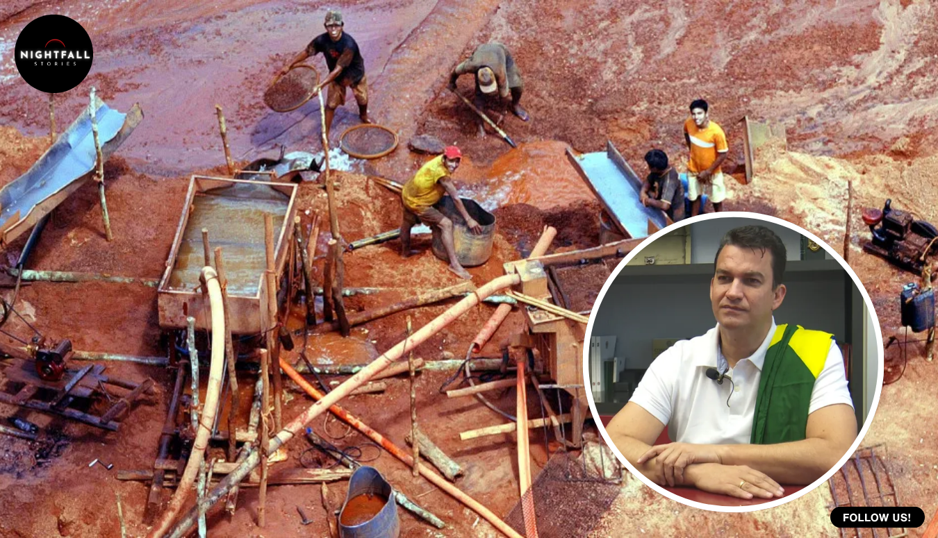
    The two people who spent three years getting it signed were not at home when it happened, because they do not have a home any more. Armed men came to their house at dawn in May, held them there for hours, smashed the solar panels and the batteries and the computers and the monitoring cameras, set fires, and fired weapons. The couple got out and walked more than fifteen kilometres through the hills. Five weeks later they were told by an anonymous tip that the place had burned again, and this time there was almost nothing left of it. Walls down, roof gone, beams gone, the mosaic in the kitchen with the name of the house in it deliberately broken up.

    Alcione Figueiredo Correa is an engineer. Marcos Fantini is a lawyer who works on environmental and human rights cases. Together they ran Toca do Lobo, an outpost of the UNESCO Atlantic Forest biosphere reserve network that functioned as a small eco-tourism lodge, a monitoring station, and their house. In 2023 they started a campaign with a name that was also its entire argument, Salve a Serra da Chapadinha. Save the Chapadinha range. Three years later the range is a legally constituted conservation unit and they are among the many people who cannot sleep there.

    That is the shape of the story, and it would be enough. But the thing the campaigners talk about first, when asked what they actually won, is not the perimeter. It is a single clause buried in the third article of the decree, and it concerns what is underneath the ground rather than what is on top of it.

    Start with the water, because without the water nothing about this makes sense to anyone who has never heard of the Chapadinha. The range is a block of high ground in the interior of Bahia, well away from the coast, and it is a sponge. Rain lands on it, soaks into it, and comes out lower down as springs and waterfalls that feed the Una river, which feeds the Paraguacu, which is the river that keeps a very large part of the Bahian semi-arid interior and a very large part of its coastal capital in drinking water. The figure that appears across the reporting is more than eighty municipalities, Salvador and its metropolitan region among them. Around sixty per cent of the metropolitan supply is drawn from that basin.

    So this is not a scenic question. A mountain nobody outside the state has heard of is the tap for a city of millions. That single relationship is why a public prosecutor eventually got involved, why a state deputy eventually installed a parliamentary front in the Bahia legislative assembly, and why two people who ran a small lodge found themselves at the centre of something that got them burned out.

    The sequence is documentable rather than vague, which matters in a story where almost everything else is contested. The campaign began in 2023, and in the same year the Federal Public Ministry issued a recommendation on the area. A first public hearing was held in the middle of 2024. A formal public consultation on creating the refuge opened at the start of June this year. A parliamentary front in defence of the Serra da Chapadinha was installed at the state assembly, with state deputy Hilton Coelho attached to it. And on 31 August the decree was signed, appearing in the state official gazette the following day. Three years from a pair of residents deciding to make a noise, to a numbered state instrument.

    Correa and Fantini also got in front of the people who could move it. One photograph from the process shows the pair standing with the Bahia environment secretary and with the president of Brazil. Former environment minister Marina Silva is named in the campaign’s own account of its supporters. It is worth being careful about that, because famous names tend to swallow a story. The decree is a state instrument signed by the governor of Bahia, Jeronimo Rodrigues. Federal support helped. Federal support did not do the work.

    Now the attacks, told plainly and then left alone, because there is nothing to be gained from reconstructing a fire.

    On the first of May this year, in the early hours, around seven men arrived at the house with their faces covered and with rifles. They held Correa and Fantini for roughly two hours. They destroyed the energy system and the communications gear, the hard drives, the radios and the cameras that the couple used to document what was happening on the range. The structure itself was badly damaged. According to the couple’s account, the men told them that their preservation work was getting in the way of progress and in the way of mining going in. On the fifth of June, with the public consultation on the refuge barely open, the house burned a second time, and when environmental staff reached it there was little standing.

    Who did it has not been established. The police inquiry into the first attack is under judicial secrecy, and no indictment has been reported. Every account that can be reached frames mining and land interests as the pressure on the area in general, which is a description of a context and not an identification of a person. Correa has said she believes the second attack was retaliation for the consultation opening. That is a belief, held by someone with every reason to hold it, and it is not a finding. The honest position at the time of writing is that the attacks are unresolved, and the honest thing to do with that position is to state it and stop.

    Which brings the story back to the clause.

    A conservation decree in Brazil, as a rule, governs the surface. It says what may happen on the ground inside a line. It restricts building, clearing, hunting, certain kinds of use. According to the reporting on decree 24,778, including an account from Brasil de Fato that cites the third article and its single closing paragraph, this one also expressly brings the subsoil of the defined area inside the protected perimeter. Mining is named among the activities declared incompatible with the refuge. Visiting, research and environmental education are named among the compatible ones. Management is assigned to the state environment and water resources institute, Inema, and a management plan is required within five years.

    The category itself was a choice, and it is worth a sentence. A national park is the instrument most people imagine for a landscape like this, and a park requires the state to take the land, which in practice means money, expropriation files and years. A wildlife refuge sits in the same full protection group in Brazilian law but is built to tolerate existing private holdings inside its boundary, provided their use is compatible with the refuge’s purpose. That makes it faster to declare and much harder to enforce, which is precisely the trade that has played out here.

    It also lets the line be drawn wide, which was the other thing the campaign wanted. The refuge is not a fence around one scenic valley. It spans four municipalities and is intended to work as a corridor, keeping blocks of habitat on the Chapada connected to each other rather than leaving them as islands with farmland in between. Ecologists have spent decades establishing that an isolated patch loses species it should by all rights be able to hold, simply because nothing can move in or out of it. A corridor is the cheap answer to that, and corridors only exist if somebody draws them before the gaps close.

    Claudio Dourado of the Pastoral Land Commission, who has been one of the most consistent voices on the area, is the person on record about that subsoil line. What he actually said was that he does not know of another decree that does it. That is a careful sentence by a man who works on land conflict, and it is not the same sentence as the one that has been circulating.

    The circulating version is that the clause is legally unprecedented. It is worth taking that superlative apart, because the piece that is genuinely interesting here survives the dismantling and the superlative does not.

    First, the easy part. A refuge of this category, a Refugio de Vida Silvestre, is not a loose designation. Brazil’s national system of conservation units law of 2000 lists it among five categories in the full protection group, alongside national parks and biological reserves, and the law says the basic objective of that group is to preserve nature with only indirect use of natural resources permitted. Mining inside a full protection unit is already incompatible with the category under federal law. The decree naming mining as prohibited is not an innovation. It is a restatement of what the category already means.

    Second, the harder part, and the reason the clause cannot do what the most enthusiastic readings want it to do. Under Brazil’s federal constitution, mineral resources in the ground are not an attribute of the land above them. They are the property of the Union, and the right to research and extract them is granted federally, through a federal mining authority, separately from whoever owns the surface. A state governor does not have the pen for that. So a Bahian decree declaring that the refuge includes the subsoil is not a state seizing the mineral estate. It is a state putting itself on record, in a binding instrument of its own, that in its view the rock under this particular mountain is part of a protected area and cannot be opened without colliding with that instrument.

    That is a drafting move rather than a new power, and it is a genuinely useful one. The ordinary problem campaigners run into is precisely that a surface protection leaves claims in the federal register substantially alive underneath it, so the fight has to be had again every time somebody files. Writing the subsoil into the perimeter does not cancel those claims. It does mean that anybody arguing for them has to argue against the text of a state decree, in front of prosecutors who have already taken an interest, rather than against a management preference. Whether that holds up is a question for courts, and it has not been tested.

    One thing should be said straight. The full text of decree 24,778 could not be obtained from the Bahia state official gazette or the state legislation portal while writing this. Everything above about the clause rests on reporting that cites the article and paragraph, and on a campaigner’s description of what it covers. The number, the date, the area, the four municipalities, the management body, the five-year plan deadline and the prohibition on mining are all corroborated across independent accounts including government-sourced ones. The exact wording of the subsoil paragraph is not in hand, and until it is, the clause should be read as reported rather than as quoted.

    There is one more thing in the law that explains why nobody there feels finished. The same national system statute allows private property to remain inside a wildlife refuge where its use is compatible with the refuge’s objectives, and requires expropriation where it is not. A refuge is drawn over a living landscape with owners and occupiers in it. The decree’s consultative council is designed to seat landowners, public bodies, civil society, agrarian reform settlers and traditional peoples at the same table. None of that resolves a land dispute. It formalises one.

    So the decree is a document. In the weeks after it was signed, reporting from the Chapada found the territory in roughly the condition it had been in before: no management plan written, no fixed operational base, no manager appointed, no environmental education programme for the surrounding communities, no visible enforcement presence. Gislene Moreira of the Chapada Diamantina Observatory has made the point that what the area needs is actual territorial pacification rather than a signature. Renato Cunha of the Bahia environmental group Gamba has pressed on the two concrete absences, the plan and the people on the ground. Correa’s own summary, after three years and two fires, was that it is lovely to say the decree has been made, and what is needed is for the state to occupy the territory. She described the place as a land without law. She asked for a presence within a month.

    That is where it sits. Two residents of a mountain range in the interior of Bahia started a campaign in 2023 because the springs that supply a capital city were under pressure. They were held at gunpoint and their house was burned, twice, and nobody has been charged. They kept going. They got a federal prosecutor to treat the refuge as a priority, a state deputy to open a parliamentary front, a public consultation, and finally a numbered state decree protecting about 18,300 hectares, with an unusual line in it about the rock underneath.

    They also got the only ending that is honest about what a decree is. It is not protection. It is permission to demand protection, written down somewhere that can be pointed at. The two people who won it now have the job of making the state turn up to the thing it signed, and they have to do that from somewhere other than home.

  • He paid high school students to copy Star Wars onto papyrus, then set the whole thing on fire

    He paid high school students to copy Star Wars onto papyrus, then set the whole thing on fire

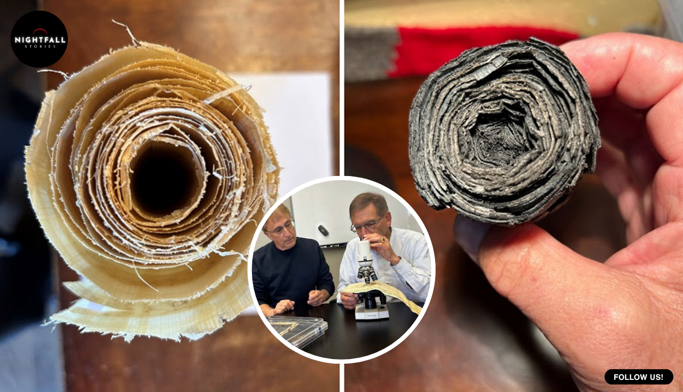
    The sentences written on the scroll were lines from Star Wars, passages from the Bible, and a stray quote from a nineteen sixties science fiction television series called The Outer Limits. They were written with reed pens on real papyrus, by high school students who were paid for the job. Then the scroll was sealed in a steel container, put in a furnace with almost no oxygen, and burned until it was a black cylinder about four centimetres across and eleven long.

    That was the point. The man behind it, Douglas Seiler, needed a charred scroll he was allowed to ruin, because the only other charred scrolls in the world are the ones nobody is allowed to touch.

    Around eighteen hundor so papyrus rolls survive from a villa at Herculaneum that was buried when Vesuvius erupted. They were not burned to ash; they were cooked into lumps of carbon, and for more than two centuries the attempts to open them physically mostly destroyed them. They are the only substantial library to survive from the ancient Mediterranean world in its original form, and almost all of them have never been read. Several collections in Italy, France and Britain hold what is left.

    The modern approach is to leave them shut and scan them. X-ray tomography takes the rolled object apart in software, layer by layer, and algorithms flatten each layer into a readable page. The Vesuvius Challenge has had real success with this, recovering portions of text that had been sealed for two thousand years. But the method is fighting its own physics. Ancient ink on these scrolls is mostly carbon black, soot and gum, sitting on papyrus that carbonisation has also turned into carbon. You are trying to photograph black writing on black paper using a technique that sees density. The letters are there. They barely register.

    Seiler’s question was not whether the scrolls could be read. It was whether some of them would be much easier to read than others, and whether you could tell which before wasting beam time on the wrong one.

    Romans did not only use soot ink. A study published a decade ago found lead in ink on Herculaneum material, and lead is a very different proposition to an X-ray machine. It is heavy, it absorbs hard, and if there is even a trace of it in the strokes of a letter, that letter stops being black on black and starts being something the scanner can actually see. Press accounts of the new work put the difference at up to twenty five times the X-ray absorption of the charred papyrus around it, which is the figure that has travelled, although the published paper itself reports the detection limits rather than quantifying that ratio.

    So: if lead ink shows up dramatically in a scan, and if you could check for lead in a scroll cheaply and without opening it, you would have a way of sorting eighteen hundred unreadable objects into the ones worth the full imaging effort and the ones that are going to stay silent.

    Testing that idea on the real scrolls is impossible, and not for want of nerve. There is no control group. Every one of them is the only copy of itself, nobody knows what any of them says, and you cannot calibrate an instrument against an unknown. To establish what lead at a given concentration looks like after carbonisation, you need an object where you already know exactly what was written, in exactly what ink, at exactly what strength.

    The hard choice in this story is the destructive one, and it is worth sitting with for a moment, because it is the opposite of how heritage science normally works. The whole discipline of reading the Herculaneum rolls has been built around not touching them. Every physical attempt to unroll one has cost material, and some of the early efforts in the eighteenth and nineteenth centuries reduced rolls to fragments in the course of getting a few lines out of them. The entire appeal of tomography is that the object survives the reading.

    Seiler’s experiment inverts that. To learn anything useful he had to build objects precious enough to behave like the real thing and then treat them as disposable. He made scrolls, wrote in them, burned them, scanned them, and will presumably never need any of them again. The destruction is the method, not an accident of it, and the reason it is defensible is that the things destroyed were his.

    Which is how a retired man with no background in papyrology ended up making papyrus and burning it.

    Seiler is an affiliate of Berkeley SETI, the search for extraterrestrial intelligence group at the University of California. He is not an astronomer by training either. He worked in real estate and banking, and he has worked as an inventor. His route into this was collaborating with the Berkeley SETI team on a telescope project, hearing about the Herculaneum scrolls along the way, and deciding more or less on a whim to find out whether the lead question could be answered experimentally.

    It would be easy and wrong to write that as an outsider embarrassing the experts. The record does not support it. What he actually did was assemble the specialists the experiment needed and put his own name first on a paper that could not have existed without them. The study was published in PLOS ONE and the author list runs six deep. Jacob LaManna, at the National Institute of Standards and Technology, ran the X-ray imaging, and is the person photographed in the paper placing the burned scroll on the instrument. Michael McOsker, a papyrologist in the Greek and Latin department at University College London, is a co author. David Kreimer, of Berkeley’s College of Chemistry microanalytical facility, handled the analytical chemistry side. Michael Cyrus Daugherty is also at NIST, and Jens Dopke is at the Rutherford Appleton Laboratory in England.

    The papyrology was inside the project from the start, in other words, not standing outside it with its arms folded. A Berkeley graduate student and papyrologist, Leah Packard-Grams, consulted on the work and described its value as practically unquantifiable, on the grounds that the stakes here are the largest in the history of Greek literature. That is a strong claim and it comes from the discipline, not from the engineer. Karl van Bibber, a nuclear engineering professor at Berkeley, advised Seiler informally on imaging and on how to get a result published. He appears in one of the paper’s photographs checking ink density, and he is deliberately not listed as an author.

    The method had to be faithful enough to be worth anything. The papyrus sheets were manufactured in and bought from Egypt, ten metres of it, about thirty centimetres wide. The reed pens came from Egypt too. The base ink was a carbon black ink made in Japan, the traditional lampblack type.

    Then came the students with the Star Wars lines. It is a funny detail and it is also a serious one, because what matters about the text is not what it says but that somebody knows, exactly and in advance, what is written in which ink at which position on which layer. A control sample has to be boring on the inside. It can be whatever it likes on the surface.

    Across the test pieces the ink was spiked with lead at controlled concentrations, with the strongest formulation carrying one hundred micrograms of elemental lead per two microlitres, equivalent to fifty grams per litre. The reference point mattered: earlier analysis of actual ancient samples had estimated lead in the letters at around eighty four micrograms per square centimetre on a larger sample and about sixteen on a smaller one. Seiler’s team needed to know whether traces at that sort of order would survive being cooked and still show.

    Carbonisation was done by heating the papyrus in a semi sealed steel container inside a high temperature furnace with little or no oxygen reaching it from outside. That is an approximation of what happened at Herculaneum, where superheated volcanic material cooked organic matter without burning it in open air.

    The scroll came out of the furnace as a black cylinder. It also came out, in the paper’s own words, with tight packing of its layers and a waviness that will challenge unrolling algorithms. That sentence is printed in the caption of the paper’s fourth figure, which is an unusual thing for a team to volunteer about its own successful experiment. The replica is not an easy object. If anything it is a reminder that the software problem and the ink problem are separate, and solving one does not retire the other.

    The replica itself was deliberately scaled to the problem. The burned cylinder measured about forty millimetres across and a hundred and ten long, which puts it in the same physical class as the objects it stands in for rather than being a convenient flat test strip. A flat strip would have answered a much easier question. The difficulty with a real scroll is that the writing is wrapped around itself dozens of times, each layer pressed against the next, with the surfaces warped by heat, and the software has to decide where one layer ends and the next begins before it can even start reading. Making a rolled, cooked, warped object was the only way to put that difficulty into the test.

    At NIST the burned scroll was scanned, and then virtually unrolled: a program follows the curvature of the layers with drawn splines, flattens them, and produces a readable surface. The leaded writing appeared. Seiler has described the letters as lighting up, and the lowest concentration the team tested, twenty five micrograms per square centimetre, was still visible. That is the number the result rests on, and it comes with an honest caveat built in: twenty five is not the detection floor, it is simply the weakest ink they tried. The method might see less. Nobody has established how much less.

    The quieter half of the work is arguably the more useful. After the scan, the team went over the carbonised scroll with a handheld X-ray fluorescence unit, an Olympus instrument of the kind used in the field, and it picked up the lead. Not a synchrotron, not a beamline with a six month waiting list. A device a person can carry into a library.

    That is what turns a laboratory finding into something a collection could act on. If a conservator can walk along a shelf of unopened Herculaneum rolls with a handheld scanner and come away with a list of which ones contain lead, then the enormously expensive imaging effort can be aimed rather than guessed. The authors are frank that this is not yet practical as described: more work is needed, they write, to develop a more efficient or automated way of scanning scrolls with a handheld unit. Walking an instrument over a fragile carbon cylinder by hand, point by point, is not a workflow.

    It is worth being exact about what has and has not happened here, because the easy version of this story is wrong in a way that matters. No new ancient text has been read. Nothing was recovered from a real Herculaneum scroll. What exists is a detection and screening method, validated on an object that was built to be destroyed, and an argument that lead in ancient ink would make reading these scrolls substantially more likely to succeed.

    The paper is careful about the gap. The real question it opens is a question about the scrolls rather than about the technique: how many of the surviving eighteen hundred contain enough lead to matter. Nobody knows. The collection has never been systematically screened for it, which is precisely the task the handheld result suggests.

    There is one image in the paper that sits slightly apart from the rest of it. Among the furnace shots and the X-ray projections and the unrolling screenshots, there is a photograph of McOsker, the papyrologist, examining a Herculaneum papyrus that was unrolled long ago, PHer. 1012, a copy of Demetrios Lacon’s work on poems. It is an object that has already been opened and read, which makes it the counterexample to everything else in the study. It is what the rest of the library is not.

    Two of the practical details are worth keeping, because they say something about how this kind of work gets done now. The journal released the whole paper under a public domain dedication, meaning the authors kept no copyright in it at all, so the figures and the data are free for anyone to build on. And the original problem was solved by someone who had no professional reason to care, who bought papyrus from Egypt and ink from Japan with his own initiative, paid teenagers to write nonsense on it in a dead medium, and then put it in a furnace.

    The Herculaneum library has defeated serious scholars for two hundred and fifty years, and it is not defeated yet. But there is now a cheap test for whether a given scroll is likely to give itself up, and the test exists because somebody was willing to make the thing he wanted to read, and then burn it.

  • They were taught that their minds stopped developing at 18. Then six of them walked out of a university with bachelor’s degrees

    They were taught that their minds stopped developing at 18. Then six of them walked out of a university with bachelor’s degrees

    Ruti Bar-Or was 46 when she collected a bachelor’s degree in social sciences. She is a poet and keeps a diary, she has Down syndrome, and for most of her life the standard professional literature said the thing she had just done was not possible. Not difficult. Not unlikely. Not possible, because the cognitive development of people like her was supposed to have finished somewhere around the end of adolescence, and what came after that was supposed to be a long flat line and then a decline starting in the mid thirties.

    She was one of six. Tomer Gad-Barak, 35, who has mild cerebral palsy. Hofit Gilad, 41, a mother who turned out to have a head for statistics. Henia Greengarten, 42, who has Kabuki syndrome and volunteers in preschools. Oded Naftali, 34, a military veteran with Down syndrome. Lior Shmualevitz, 35, who has Williams syndrome. All six were registered as regular students at Bar-Ilan University in Israel, all six sat the courses, and after roughly ten years of study all six were awarded a multidisciplinary BA in social sciences through the university’s Faculty of Education.

    The researcher who built the road they walked down is Professor Hefziba Lifshitz, and earlier this year the President of Israel put a medal around her neck for it. That part is easy to report. The harder and more interesting part is what she actually proved, because the temptation with a story like this is to turn it into a single heroic act of overturning, and that is not what happened. What happened was slower, more argumentative, and more useful.

    Start with the assumption, because the assumption is the story. If you trained as a special educator or a clinical psychologist in most of the second half of the twentieth century, you were taught a developmental trajectory for intellectual disability that had three parts. Restricted cognitive growth up to roughly the age of 20. Then stability. Then accelerated decline from the mid thirties or forties onward, with signs of dementia appearing in people’s thirties and forties. That was not folklore. It came out of research literature going back to the 1960s, and Lifshitz’s own papers cite it directly as the position she was arguing against.

    Think about what a trajectory like that does once it is inside a system. If development is over at 20, then everything after 20 is maintenance. You do not design a curriculum for a 35 year old, because there is nothing left to teach that will take. You design occupation, supervision, pleasant activity, safety. Money follows the model. Staffing follows the model. Expectations follow the model, and expectations are the part that gets into people’s heads and stays there. An adult with an intellectual disability who wanted to study something new was, under that framework, asking for a kindness rather than an education.

    Lifshitz’s counter-proposal has a name. She published it in 2015, under the surname Lifshitz-Vahav, as Compensation Age Theory, in the journal Education and Training in Autism and Developmental Disabilities. The core claim is deliberately modest in its wording and large in its consequences. It is that chronological age, not mental age, is the variable that matters for adult cognitive performance in this population, and that all human beings, including people with intellectual disability and including older ones, remain capable of change given the right environmental conditions and systematic intervention. Her formulation is that adulthood involves processes of development, growth and neural sprouting rather than stagnation or decline. Her clinical estimate, drawn from her own data, is that measured intelligence in this population tends to peak somewhere around 40 to 45, which is to say two decades after the textbooks had it finishing.

    The evidence behind that arrived in pieces over a long stretch, and it is worth walking through the pieces, because the quality of each one is different and an honest account says so.

    The largest single study came in 2024 in Scientific Reports, with Lifshitz as lead author alongside Roi Yozevitch of Ariel University and Shlomit Shnitzer-Meirovich of Levinsky College of Education. It compared 340 people with intellectual disability, 79 of them with Down syndrome and 261 with intellectual disability of non-specific origin, across an IQ range of 43 to 75. The sample split into an adolescent group aged 16 to 21 and an adult group aged 22 to 45, and the researchers put both through standard measures of acquired knowledge and of problem solving: vocabulary, similarities, block design, Raven’s matrices.

    The adults outperformed the adolescents on three of the four measures. That is the headline result, and it runs in exactly the opposite direction to the trajectory the field had taught. A second finding surprised the researchers more. Participants with Down syndrome, long characterised in the literature as having relatively weak non-verbal reasoning, did better than the non-specific group on block design and on Raven’s matrices, and a network analysis of how the two kinds of intelligence related to each other showed a more coherent, more integrated pattern in the Down syndrome group than in the comparison group, whose pattern was diffuse.

    Now the honesty. That study is cross-sectional. It compared different people of different ages at one moment, rather than following the same people as they aged, and the authors say plainly in their own limitations section that this design cannot establish causation and that cohort effects between the age groups are a live possibility. The adults in that sample grew up in a different service system from the adolescents, and some of the gap could be the system rather than the ageing. The Down syndrome subgroup, at 79 people, is small. The IQ range covers mild and moderate disability only. None of that is a reporter’s objection. It is the paper’s own.

    Which is why the intervention studies matter more, and they are smaller. In 2018, in PLOS ONE, Lifshitz and colleagues including Jay Verkuilen of the City University of New York compared two groups of adults who had come through different versions of university study: 10 who had been fully included in regular courses and 21 who had taken adapted enrichment courses. The fully included group, aged 26 to 51, scored a mean general IQ of 68.7 against 56.6 for the adapted group, and a mean verbal IQ of 72.9 against 59.7. That is a gap, not a change, and selection could easily explain some of it, since the stronger students were the ones who went into full inclusion in the first place.

    In 2023, in the European Journal of Special Needs Education, the team tested the same question with a before and after design. Twelve adults with mild intellectual disability who went through four and a half years of the university programme were compared with twelve who did not. The programme group’s scores rose. Lifshitz’s account of it is that among the students pursuing a BA, the second IQ measurement crossed the 70 to 75 threshold that the definition of intellectual disability itself sits on, landing at 80 and in some cases higher. One report of the programme’s third stage put the increase as high as 15 points, with verbal scores reaching the nineties.

    That finding deserves to be read carefully rather than enthusiastically. Twelve and twelve is a very small study, nobody was randomly assigned, and an IQ score crossing a diagnostic cutoff is not the same as a diagnosis being withdrawn or a life being transformed. What it does mean is that the number which the system treated as a fixed property of a person moved, measurably, in adults in their thirties and forties, after education. The flat line was not flat.

    The study that pushed hardest against the old model came last year, in Research in Developmental Disabilities, and it went after the group that the deficit framework had written off most completely. Lifshitz, with Shira Posner and Shnitzer-Meirovich, ran an introduction to sociology course, built around an e-book and a mediational teaching strategy, for nine adults with severe intellectual disability and extensive support needs, aged 27 to 58, against ten controls. The students gained academic knowledge, which you might expect from a course. More unexpectedly, the gains showed what the researchers call near transfer onto basic cognitive measures, while the control group stayed flat or slipped. Nine people. The authors say so, and say generalisation should be cautious.

    So the fair summary is this. A specific, consequential, widely taught claim about when development ends has been contradicted by a consistent body of work, most of it from one research group, much of it on small samples, with designs that establish that change is possible rather than that it is universal. That is a real result. It is not a cure, nobody involved has claimed it is, and the field’s acceptance is best measured by the fact that a mainstream academic publisher, Springer, brought out her full monograph on it in 2020, under the title Growth and Development in Adulthood among Persons with Intellectual Disability, with a chapter devoted to cognitive rehabilitation for older people with intellectual disability and Alzheimer’s disease.

    That chapter is the sign of a researcher arguing in good faith, because the decline literature did not evaporate. It is strong and it is specific. A large American cohort study published in JAMA Network Open in 2024, drawing on claims data covering 132,720 adults with Down syndrome, found that 23.3 percent had ever received an Alzheimer dementia diagnosis, with a mean age at first diagnosis of 54.5 years. Among those who were 55 to 64 when they entered the study, the probability of an Alzheimer diagnosis over the following eight years was 63 percent. Early onset dementia in Down syndrome is not an old prejudice that better research dissolved. It is a documented medical reality with a genetic mechanism behind it.

    Both things are true at once, and holding both is the whole intellectual achievement. Development can continue into the forties and the risk of a steep decline can arrive in the fifties. What the old trajectory got wrong was not the existence of decline. It was the dates, and the assumption that the two decades in between were dead ground.

    Which brings us to the second step, the one that is much harder than publishing. In 2012 Lifshitz started a programme at Bar-Ilan called Otzmot, which translates roughly as strengths or powers, and is presented in English as the Empowerment project. It did not begin as a gesture. It began as the obvious operational consequence of her own data: if adults keep developing, enrol them.

    By her own account, that drew scepticism from parts of the academy. It is not difficult to see why. A university is a machine for sorting people by measured ability, and the proposal was to run students through it whose measured ability put them outside the entry criteria by definition.

    The programme is built in three stages, and the design is the interesting part. The first stage puts students into academic courses adapted for them at the university’s school of education: introduction to psychology, introduction to sociology, self-advocacy, library and computer skills. The teaching is largely done by master’s students in the intellectual disability programme, who are trained in curriculum adaptation first, which means the adaptation is a taught professional skill rather than improvisation. The second stage puts Otzmot students into BA research seminars alongside typical students, working on research together. The third stage registers the strongest students as regular undergraduates working toward a degree.

    Note what is adapted and what is not. The route in is adapted, the materials are adapted, the pacing and the mediation are adapted. The subject matter is not watered into something else, and the degree at the end is a real degree from a real faculty, not a certificate of attendance. That distinction is the difference between a programme and a courtesy.

    It now runs at a scale that is no longer experimental. Around 120 adults are enrolled across the full range of disability severity, from mild and moderate through to severe with extensive support needs, under director Dr Shoshana Nissim. Lifshitz also heads the Machado Center for Research and Advancement of Variability and the Baker Center at Bar-Ilan, where the research and the teaching feed each other, which is why the intervention studies exist at all: the students are not case studies, they are enrolled adults whose results are measured the way any educational outcome is measured.

    The six graduates collected their degrees in 2024, at a ceremony the country’s first lady attended. Lifshitz has said she is aware of only three other people anywhere in the world who hold a BA having met comparable criteria, which is a statement about how closed the door has been rather than about how rare the people are.

    Earlier this year the Israeli Presidential Medal of Honor went to eleven people, and she was one of them. The award is the state’s highest civilian decoration, established in 2012 and revived by President Isaac Herzog after a long gap, and it is given on the recommendation of an advisory committee chaired by the retired Supreme Court justice Professor Yoram Danziger, which considers nominations against published criteria for an exceptional contribution to the country or to humanity. There is no public vote, no entry form and no fee, which is a lower bar to clear in a story than it sounds, and a lot of awards do not clear it. The others honoured alongside her were Yona Elian-Keshet, Hossam Haick, Mooli Lahad, Yossi Leshem, Abie Moses, Ziva Mekonen, Moshe Nissim, Rabbi Haim Sabato, Yehuda Eder and Uriel Reichman. Herzog told the recipients that each of them was a beacon in their field.

    The medal is the recorded ending, but it is not the point, and Lifshitz would be an odd person to turn into the moral of her own research. The point is that a number in a textbook was wrong, and that being wrong about it had a cost nobody was counting. For decades, adults who could have been learning something were handed activities instead, on the authority of a developmental ceiling that had been measured badly and then repeated confidently. Six people with a social sciences degree each are not proof that everyone should have one, and nobody serious is arguing that. They are proof that the ceiling was never where the field had drawn it, and that the only way anyone was ever going to find out was by teaching the people on the other side of it and seeing what happened.

    What happened is that they learned. The rest was paperwork.

  • A bus with 21 people aboard came down the hill with no control. The lorry driver in front could see it coming, and he chose not to get out of the way.

    A bus with 21 people aboard came down the hill with no control. The lorry driver in front could see it coming, and he chose not to get out of the way.

    At roughly twenty-six minutes past six in the evening, a dashcam in traffic on the North-South Expressway in the Malaysian state of Perak recorded something most drivers will never see and would not know what to do with. An express bus, running south out of Kedah towards Kuala Lumpur, was coming down the long descent near the Menora Tunnel and it was no longer being driven. It was simply moving. It struck a guardrail. It came close to several smaller cars. And ahead of it, in the right-hand lane, a loaded lorry slid sideways into its path rather than away from it.

    That was deliberate. The lorry driver, Wong Tuck Meng, forty, had worked out what was behind him and had decided that the back of his own vehicle was going to be the brake. The bus hit his rear. Both vehicles slowed together. He kept the pair of them against the barrier until they stopped. There were twenty-one people on the bus.

    Eight days later he was standing inside the national Parliament building in Kuala Lumpur, being handed a certificate and the equivalent of about 2,150 US dollars.

    The clean version of this story, the one that travelled, is a man who sacrificed his truck to save a bus. That version is true as far as it goes, and it is also the least interesting thing about it, because it skips the part that actually took nerve. Wong did not stop a bus. Nobody stops a bus. What he did was choose where and how it would come to rest, and he made that choice in the handful of seconds available to him while sitting inside one of the two objects involved.

    Start with what a runaway vehicle on a gradient is. A fully loaded express coach is a very large amount of mass moving at highway speed, and on a downhill run gravity is adding to that every second rather than taking from it. The only question left is what absorbs the energy. If nothing does, the vehicle keeps accelerating until the road geometry decides for it, which on a mountain descent usually means a curve it cannot hold. A guardrail is not there to stop a coach. It is there to keep one from leaving the carriageway. The barrier buys you a direction, not a halt.

    What a lorry in front offers is something a barrier cannot: it offers mass moving in the same direction. Contact between two vehicles travelling the same way is an enormously gentler event than contact between a moving vehicle and anything fixed, because the closing speed is only the difference between them rather than the full speed of the faster one. The lorry then has its own brakes and its own traction to spend, and because it is in front, every bit of braking it does is braking the thing behind it too. That is the whole mechanism. It is crude and it works and it is also the reason runaway lanes on steep highways are filled with gravel rather than walls.

    Understanding it afterwards, in writing, is easy. Working it out in the mirror is not.

    The place itself is worth a moment, because the geography is not incidental. The Menora Tunnel is a pair of eight-hundred-metre bores driven under the Keledang Range near Jelapang, two lanes in each direction, open since the late nineteen eighties. It is the point where the main expressway up the western side of the peninsula stops going around the hills and goes through them, and either side of it the road climbs and falls hard. Every express coach running between the northern states and the capital uses this stretch, which means that on any given evening there are dozens of heavy vehicles on a long gradient with a tunnel mouth at one end of it. Drivers who work the route know exactly which section they are on without looking. That is the stretch where this bus stopped being a bus and became a weight.

    Wong’s own account of the moment, as he gave it to reporters at Parliament, is unglamorous in a way that reads as honest. He said he had a little distance to work with because the bus was still some way back, so he used it to sound his horn and give the cars in front of him a chance to move out. That is the detail that tells you he was thinking about the whole road and not only about himself. His first action in a situation he had no training for was to clear the space downstream, because he already knew he was about to become an obstruction.

    He also said, more or less, that you only really think about one thing in that situation, which is that a crash with people dying in it has to be avoided if there is any way to avoid it. He did not frame it as courage. He framed it as the available option.

    There is a second driver in this story and he is usually left out of it. The man at the wheel of the bus, named in one Malaysian daily as Ahmad Yasin Ab Malek, gave his own version, and it is the version that completes the picture. He said he tried to hold himself together once he realised he had lost control, moved across into the right-hand lane, and judged that the lorry ahead of him was the safest thing available to him. That matters enormously. This was not a passive object hitting a volunteer. Two professional drivers, strangers, in different vehicles, with no radio between them, arrived independently at the same plan and executed it in traffic. One steered towards the lorry. The other steered towards the bus.

    That is the part worth sitting with. Road rescue is usually told as one hero and a crowd of victims. This one needed two people to be right at the same time, and nobody had time to agree anything.

    Now the honest limits, because this story has been circulated with more certainty than the record supports, and the gaps are not small ones.

    Nobody has published what went wrong with the bus. The Malaysian reports describe a technical failure and a loss of control on a descent, and that is as far as the sourcing goes. Whether that was a brake problem, and if so whether it was wear, overheating on the gradient, a mechanical fault, a maintenance failure or something else entirely, is not established in anything that has been made public. The operator has not been named in the coverage. No investigation finding has been released. Anyone telling you the brakes failed because of one specific cause is filling in a blank.

    More importantly, and this is the detail that keeps getting invented: it is not on the record whether anyone was hurt. When the footage first circulated, the clearest contemporaneous write-up said plainly that it remained unclear whether anyone had been injured or what had caused the bus to lose control. The later award coverage says the passengers were spared a far worse outcome and that lives were saved. It does not say that nobody was hurt, and neither does the wire copy, and neither does any of the papers. Twenty-one people were inside a large vehicle that hit a guardrail and then hit a lorry. The responsible thing to say is that no deaths have been reported from this incident and no injury figure has been published either way. The cheerful line that everyone walked away is not something anyone has actually reported.

    There is also a cost side to this that nobody has published, and it is worth naming because it is the part that makes the decision a real one rather than a free gesture. A lorry is not a prop. For a man who drives goods for a living, that vehicle is the income, and letting a coach run into the back of it is a decision to damage the thing he is paid with. Depending on how the load was secured, it is also a decision to accept whatever the impact did to the cargo. None of the reporting says what happened to his lorry, what it cost to repair, who paid, how long he was off the road, or whether the award money came anywhere near covering it. Ten thousand ringgit is a serious sum in that trade and it is also not a lot of bodywork. He will have known the general shape of that arithmetic as he moved across, and he moved across anyway.

    What is on the record, in detail, is what happened eight days afterwards.

    On the twenty-third of June, Wong was brought to the Parliament building and presented with two things from the Road Safety Council of Malaysia: a special certificate of appreciation, and a road safety hero award. With them came ten thousand ringgit, about 2,150 dollars, paid out of the council’s fund. The transport minister, Anthony Loke, said in substance that a tragedy had been avoided and many lives saved because one driver acted quickly even though doing so could have cost him his own. A letter of appreciation went into the parliamentary record.

    There is a wrinkle here that should be reported rather than smoothed over, because two Malaysian outlets do not agree on who handed over what. The national news agency, along with three separate newspaper groups that sent their own reporters, has the transport minister making the presentation, with the deputy speaker of the lower house, Ramli Mohd Nor, conveying Parliament’s own appreciation separately. One major Malay-language daily instead describes the deputy speaker as the one who presented the award. Both officials were plainly there and both plainly took part. Which hand passed the certificate is the sort of detail that gets garbled in a scrum of photographers, and the balance of the reporting favours the minister presenting, but it has not been settled by any primary document, so the fair version is that both men took part in honouring him and the accounts differ on the choreography.

    The same caution applies to his name, which is a small thing that matters a great deal if you are the person it belongs to. Five of the Malaysian outlets covering this, including the national wire and three papers working independently, spell it Wong Tuck Meng. One spells it Wong Tuck Ming. I could not retrieve a published citation from the Road Safety Council or the transport ministry that would settle it from the awarding side, which is where it should be settled. Tuck Meng is the spelling carried by the clear majority and by the wire, and it is the one used here, but it is a weight of usage rather than an official confirmation, and it is worth saying so out loud.

    It is also worth being honest about how many eyes have actually been on this. The story looks heavily covered, and in a sense it is: it appeared across a dozen sites in two languages within a day. But most of that is the same wire copy under different mastheads, and two of the titles that carried it belong to the same group. Stripped down, the real base is the national news agency plus a handful of papers that put their own reporters and photographers in the room at Parliament. That is enough to stand on. It is not the twelve independent accounts the search results suggest, and the difference matters when the thing you are checking is a detail only one of them has.

    One more thing is absent and its absence is the reason the clip travelled. Nobody knows who filmed it. The footage that put Wong on the national record came from a dashcam in following traffic, and the person behind that camera has never been identified in any of the coverage. They happened to be on that stretch of road at that moment, pointed the right way, and their recording is the only reason a lorry driver’s decision became a public act rather than a private one and an insurance claim. He got a certificate in Parliament. They got nothing, because nobody knows who to give it to.

    The backdrop to all of this is less comfortable. Almost exactly a year before, in the same state, a chartered bus carrying university students home after a holiday lost control on a dark downhill curve, hit a guardrail and came to rest near a ravine. Fifteen students died. More than thirty people were injured. The operator’s licence and permits were pulled, the driver was charged, and there was a long national argument about who is accountable when a coach full of people goes off a hill. That is the context in which a country gives a lorry driver money and a certificate for a descent that did not end that way. The Road Safety Council exists partly because these roads keep producing this exact geometry: a long gradient, a heavy vehicle, a barrier and a curve.

    Which is why the award is a slightly odd object, and interesting for it. It is not a jury prize with published judges and a methodology. It is a statutory council and a government ministry deciding, quickly, that a particular act deserved public money and the floor of Parliament. Somebody other than Wong decided it, there was no application and no nomination fee and no popularity vote, and the whole thing went on the parliamentary record with a date attached. Eight days from the deed to the certificate is fast for any government anywhere. Somebody in that system watched the clip, found the man, and pushed it through.

    What strikes me, reading all of it, is how little room there was. Wong did not have a minute. He had the length of a mirror glance to understand the problem, decide that the solution was his own vehicle, sound his horn for the cars ahead, and position himself. Whatever he feels about it now, at the time it was a small number of seconds and a choice between being somewhere else and being the thing that stopped it.

    He chose to be the thing that stopped it. And then, eight days later, a man who drives goods for a living stood on a floor built for politicians while the transport minister explained to the country what he had done, which is not where that Monday evening on the expressway looked like it was going.

  • She has taught English in the same Irpin classroom for thirty years. The rule she follows for the first two minutes of every lesson is the part nobody expected

    She has taught English in the same Irpin classroom for thirty years. The rule she follows for the first two minutes of every lesson is the part nobody expected

    Svitlana Merkulova teaches English at Lyceum No. 2 in Irpin, a town on the north western edge of Kyiv, and she has been teaching in that building for thirty years. This year a panel reviewing 1,169 applications and 1,723 nominations named her the best teacher in Ukraine and handed her a million hryvnia, a little over twenty thousand dollars at recent exchange rates, earmarked for educational projects rather than for her. The ceremony was at the National Opera of Ukraine. Her name was projected onto the Motherland Monument in a light show that night.

    The prize is the least interesting thing about her, and she more or less said so from the stage. The interesting part is the thirty years, and a set of working rules that are unusually well documented for a teacher, because she has spent a decade writing them down and teaching them to other people.

    Start with the one that governs how a lesson opens. Before any grammar, before any task, there is an emotional check in. Every pupil in the room says, briefly, where they are that day. It is not a pastoral add on wedged into a timetable. It is the first two minutes of the lesson, every lesson, treated as part of the method rather than as an interruption to it, and it comes out of trauma informed practice, a body of classroom technique Merkulova has also trained other Ukrainian teachers in.

    Then there is the rule she applies to herself. The teacher talks for twenty percent of the lesson and the pupils talk for eighty. That is a brutal constraint for anyone who has stood at the front of a room, because the easiest thing in the world is to fill the silence, and a teacher explaining is a teacher who can hear that the lesson is going well. Holding to one fifth means building the other four fifths out of something the pupils actually have to do.

    What she builds it out of is largely not a textbook. Her lessons use authentic material, the English that exists in the world rather than the English written for learners: menus from London cafes, airport announcements, the flat functional language of a place a pupil might one day be standing in. Tests are often replaced with quests, which in her classroom means a trail of QR codes that have to be worked through in sequence, so that the assessment looks like a game and the pupil is reading under pressure without the vocabulary of examination attached to it.

    There is a flipped classroom element too, which is the technique where the explaining happens at home and the lesson itself is spent doing the hard part with somebody there to help. It is a method with an obvious dependency, because it assumes a pupil can reliably reach the material before the lesson, and that assumption has not been a safe one in Ukraine for several years. None of the available accounts of her practice explain how she works around that, and it would be worth knowing. What is clear is that she has kept the method rather than abandoning it, which suggests she has found a way.

    Her pupils write guides to their own town in English. That one deserves a moment, because Irpin is the town in question, and a travel guide is a strange and specific thing to write about somewhere that was fought over four years ago. The exercise is the standard one that English departments everywhere set, describe your home town for a visitor, and it is doing considerably more work here than it does elsewhere. The pupils also run debates in English on artificial intelligence, and exchange letters with pupils abroad, which is an old technique that has not stopped working.

    The results are the kind that can be checked. Multiple pupils of hers have scored 200 out of 200 on the national external examination in English, which is the ceiling of the Ukrainian scale and the score that opens the competitive university places. Two of her former pupils have taken prizes at regional olympiad level. She was listed in the country’s top fifty teachers once before, several years ago, and reached the top fifty again this year, then the top ten, then the win.

    The pen pal exchanges deserve a line of their own, because they are the oldest trick in language teaching and the one that has aged best. A pupil writing to a stranger abroad has a reason to get a sentence right that no exercise can manufacture, and for a cohort whose classmates have scattered across a dozen countries in the past four years, correspondence in a shared second language is not a quaint exercise. It is how a number of them now talk to people they used to sit beside.

    Thirty years in one school building means she started in the middle of the 1990s, and the arithmetic of that is its own story. She began teaching English in a country where Russian was still the dominant second language in most classrooms and English was one option among several. She taught through its replacement by English as the default foreign language, through the arrival of the internet into a profession that had run on photocopies and cassette tapes, through a generation of curriculum reform, and then, in 2020, through a year in which the classroom became a video call for everyone in the world at once.

    And then 2022, which in Irpin was not an abstraction. The town sits directly on the north western approach to Kyiv, and it was contested and heavily damaged in the opening weeks of the full scale invasion. A large proportion of its residents left, many of them across a destroyed bridge that became one of the most widely published images of that period. Housing, infrastructure and schools took serious damage. Schooling in the area moved online where there was a connection, and into basements and shelters where there was not.

    Merkulova stayed in the profession and in the school. She has described, in her own remarks since, what the job now involves on an ordinary day: teachers who walk into a classroom, teachers who teach down a video link, teachers who carry on in a shelter while the alert sounds. She framed her own win as belonging to all of them rather than to her, which is the sort of thing prize winners say and is also, in this case, an accurate description of a labour market. She has said that mental health and emotional resilience now matter more in her room than grades do, which is a reordering of priorities that most education systems talk about and few actually implement in the first two minutes of a lesson.

    It would be easy to make her into a symbol at this point and she has not asked to be one. What is documented is narrower and more useful: a specific teacher, a specific building, thirty years, a method she can describe, and pupils whose examination scores are a matter of record.

    The method also leaves the English classroom fairly often. Merkulova co founded a project called M 18, which runs voting for children, and the scale of it is not token. More than 13,000 young voters have taken part across 91 polling stations in fifteen regions of the country. The point of an exercise like that is not the result of the ballot. It is that a child who has queued, received a paper, marked it privately and watched it counted has learned something about the mechanics of consent that cannot be taught from a civics worksheet. For a generation whose school years have been shaped by a war about exactly that question, it is a reasonable thing for a language teacher to have spent her evenings on.

    There is a cooking strand too. Her classes led into an international project called Kids in the Kitchen, which is the sort of thing that sounds like an indulgence until you consider that a cooking task is one of the few classroom activities where a teenager must give and follow precise instructions in a foreign language or the food will be wrong. She has presented her methods to colleagues in Florence and in Berlin.

    Now the prize itself, and the part that needs handling carefully, because there is a public vote attached to this award and it is not the thing that decided it.

    The Global Teacher Prize Ukraine is run by the education charity Osvitoria and this was its tenth edition. The main award runs on applications and nominations, 1,169 and 1,723 of them respectively this season, narrowed to a top fifty, then a top ten, then decided by a jury. PwC Ukraine acted as independent consultant on the selection, verifying the transparency and correctness of the process by which the winner was chosen. There is no entry fee. The decision was taken by people other than the recipient and audited by a firm with no stake in the outcome.

    The scale of those numbers is worth sitting with. One thousand one hundred and sixty nine applications and 1,723 nominations is a large field for any national teaching award, and it is a very large field for a profession that has spent four years losing people to displacement, to mobilisation and to better paid work. The ladder from that field down to a single name went through a published top fifty, in which Merkulova’s inclusion was announced locally in the summer, then a top ten, then the final decision. She had reached the top fifty once before in an earlier cycle and not gone further, which means she had already been looked at by this process and passed over, and came back.

    Separately from all of that, the prize runs a nomination called the choice of Ukrainians, decided by open public voting on the government’s Diia education portal. That vote opened in early September, and Irpin campaigned in it. The deputy mayor, Yuliia Osinska, publicly urged the town to go and vote for its own teacher, describing her as a tireless educator of thirty years’ standing. The town’s news service carried the appeal.

    That is the trap in this story and it is worth being explicit about it, because a popularity contest won by the candidate whose local government mobilised for her would be a much weaker ending than a juried award, and the two are easy to conflate when they are announced on the same night. They are not the same thing. The community vote is its own nomination, one of about ten category awards handed out at the same ceremony. Merkulova won the main prize, the million hryvnia, and the jury’s decision was announced as such and reported independently by outlets with no connection to the organisers. The win is the juried one.

    This was the tenth edition of the Ukrainian award, which takes its name and its basic shape from the international Global Teacher Prize, the million dollar teaching award that has run since the middle of the 2010s and that put the idea of a celebrity teacher into circulation. The Ukrainian version has a smaller purse and a harder job. Ten years of it means ten winners, which is a slowly accumulating body of documented practice rather than a single annual headline, and it is the reason a method like the eighty twenty rule gets written up and circulated at all instead of staying in one classroom until the teacher retires.

    One honest limitation. The prize does not appear to publish a named jury roster anywhere that can be retrieved, and nothing in the coverage names a single judge. So the strongest accurate statement about how this was decided is that a jury decided it and PwC Ukraine audited the process. That is a real standard and it is a good deal better than most teaching awards manage. It is not the same as being able to read the names, and anyone telling you it is has not looked.

    The ceremony fell on the eve of International Teachers’ Day, in an opera house, in a country where the Ministry of Education’s own problem is not finding the best teacher but keeping enough teachers in the profession at all. An award staged at that scale is doing a recruitment job as much as a celebratory one, and everybody in the building knew it. That is not cynicism about the prize. It is the reason a prize like this is worth a million hryvnia in a year when there is not much spare money about.

    What happens to the money is already specified. It goes to educational initiatives rather than into her pocket, which is how the award is structured, and she has not yet said publicly which ones.

    The part that will not change is the part she has been doing longest. At some point in the next few days, in a building in Irpin that has been her workplace since the middle of the 1990s, a group of teenagers will sit down in a room and the first thing that will happen is not a register, not a textbook and not the past perfect. It will be each of them saying, briefly, how they are. Then she will say a fifth of what is said for the next forty minutes, and they will say the rest, in a language she has spent thirty years convincing them is not a school subject but a way of talking about what comes next.

  • He supplied illegal gold mines on Yanomami land with twenty three aircraft, and a federal court finally put a six million dollar number on it. Months later, nobody had collected a cent

    He supplied illegal gold mines on Yanomami land with twenty three aircraft, and a federal court finally put a six million dollar number on it. Months later, nobody had collected a cent

    The thing that makes this case unusual is not the gold. It is the aircraft. At least twenty three of them, according to the federal prosecutors who built the case, flying people, diesel, generators, mining motors and extracted ore in and out of a protected Indigenous territory in the far north of Brazil over roughly four years. Six helicopters were seized in one enforcement operation alone, with the carcasses of five more found in two clandestine hangars. Several had their airworthiness certificates cancelled. Several had been stripped of identifying markings and modified in ways that affected their weight and balance, which is a polite aviation term for making an aircraft less safe in order to make it carry more. Investigators found wooden floors fitted inside some of them, built for one purpose, which was holding fuel drums steady in flight.

    Early last year a federal judge in the state of Roraima convicted the man who ran it. Rodrigo Martins de Mello, a businessman widely known by a nickname taken from one of his companies, was sentenced to twenty two years and seven months in closed regime for leading a criminal organisation that extracted gold and cassiterite illegally inside Yanomami Indigenous Territory, for obstructing the investigation into it, and for laundering the proceeds. Three others were convicted with him, including his son, Celso Rodrigo de Mello, and his sister, Brunna Martins de Mello, each receiving somewhere between nine and ten years, with the exact terms reported differently by different outlets. The fourth, Leonardo Kassio Arno, received a comparable sentence for direct support to the operation.

    Alongside the prison terms came the figure that made the ruling genuinely unusual. The court ordered compensation of 31,724,287 reais and 25 centavos, which at the exchange rate running at the time of the ruling came to roughly 6.1 million US dollars, and it directed that money in favour of the Yanomami people.

    It matters what kind of money that is, because the coverage has blurred it. Some reporting described the sum as a fine. It is not, or at least not primarily. It was awarded as compensation for collective moral damages, a category in Brazilian law that exists precisely for harm done to a group rather than to an identifiable individual, and that is a different legal animal from the criminal fines a sentence also carries. The distinction is not pedantry. A fine is revenue for the state. Compensation for collective moral damage is, in principle, owed to the people harmed.

    In practice, how such an award actually reaches those people is the part nobody has yet explained publicly in this case. Collective damages in Brazil frequently route through a dedicated fund rather than arriving as a transfer to a community, and the rulings that establish the award and the mechanisms that disburse it are often years apart. Every account of this judgment says the money is reverted in favour of the Yanomami. None of the available reporting sets out the actual payment route, and I am not going to invent one.

    To understand why an air fleet was necessary at all, you have to understand the geography. Yanomami Indigenous Territory covers an area larger than many countries, straddles the border region with Venezuela, and has essentially no roads. The gold is in the riverbeds. Getting a mining operation in there means getting diesel in there, and diesel is heavy. A single pump and sluice setup eats fuel continuously. Multiply that by hundreds of camps and the limiting factor on illegal mining in that landscape stops being gold geology and starts being logistics. Whoever controls the fuel flights controls the industry.

    It also explains the second mineral in the charge sheet, which most coverage of this case skips past. Cassiterite is tin ore, and tin ends up in solder, which is to say in almost every electronic device anybody owns. Gold is what gets written about because gold is dense and valuable and a single flight can carry a fortune of it. Cassiterite is the opposite. It is bulk. Moving commercially useful quantities of ore out of a roadless forest requires a great deal more lift than moving gold does, and it requires that lift repeatedly rather than occasionally. A fleet that is flying ore as well as gold is not a smuggling sideline. It is freight.

    That is the business Mello was convicted of running, and the court’s description of it is the opposite of a rough operation. Prosecutors described a solid and structured criminal organisation functioning between 2018 and 2022, using real companies, real contracts and real invoices to wrap an illegal activity in the appearance of a legal one. One of the firms in the group was an artesian well drilling company. Another was an air taxi and tourism operator which, according to reporting on the case, at points held contracts with the health ministry. An air taxi licence is a reasonable thing for a business in a roadless region to hold. It is also, if you are so inclined, a licence to fly anything anywhere and file paperwork saying it was passengers.

    The federal police operation that pulled the hangars apart happened in 2021, and the inventory from it reads less like a mining raid than a supply depot audit. More than ten thousand litres of fuel. Generators. Motors, including truck engines of the sort used to drive high pressure hoses against riverbanks. Ammunition. Provisions. The aviation regulator moved in afterwards and dismantled two hangars outright.

    What is striking, looking at the sentence, is which law did the heavy lifting. Illegal mining itself is punished lightly in Brazil. The penalties for a first offence run from roughly one to five years, and for a repeat offence they can drop to between six months and a year, which is one reason enforcement for decades resembled a revolving door. Twenty two years and seven months is not what you get for digging gold out of the wrong river. It is what you get when prosecutors successfully reframe the activity as organised crime and money laundering and charge the person at the top of the logistics chain rather than the men holding the hoses. That reframing is the actual innovation in this case, and it is the part other prosecutors will be watching.

    The wider context has to be stated, and then stated carefully. The years this operation was running were the years the situation inside the territory deteriorated to the point where the Brazilian government declared a public health emergency there. That emergency involved serious and well documented harm to Yanomami communities, and it is not this story. This story is an economic and environmental crime with a court ruling at the end of it, and it is better reported as one than as a backdrop for suffering. What is relevant and provable is narrower. Mercury and sediment from mining fouled the rivers that communities drink from and fish in. By the time enforcement arrived, around 5,564 hectares inside the territory had been damaged, and roughly ninety two per cent of that damage had already been done by the end of 2022.

    What happened after the ruling is where the case stops being a clean story about accountability.

    In the months that followed, reporting in Brazil established that Mello was not in custody. He was appealing, which under Brazilian procedure can leave a convicted defendant free while the appeal runs, and he was reportedly no longer in the country at all, with his operations said to have shifted across the border into Guyana. A federal prosecutor working on Yanomami cases summed up the broader pattern in one flat sentence, which was that nobody is locked up. He was not talking only about this defendant. Another convicted mining boss in the region received twenty six years and was similarly at liberty pending appeal. A third was sentenced to ten years and ten months and likewise not detained. Later reporting also alleged that money connected to Mello’s family had paid living costs for a fugitive former Brazilian intelligence official in the United States, an allegation that belongs to a different case and is unproven here, but which does raise the question that hangs over the six million dollar award. If funds can cross a border for that, the court’s compensation order is a number on paper until somebody finds assets.

    Collecting on an award like this is its own long project, and it is not the court’s job. Somebody has to find assets, establish that they belong to the defendant or to people holding them for him, and freeze them, across whatever jurisdictions they have been moved through. Prosecutors in the region have shown they can do this when they commit to it. The same federal unit obtained an order freezing up to 146 million reais against companies accused of cooperating with mining in the territory, and has filed a claim against a mining firm for 1.7 billion. Those are vastly larger numbers than this ruling’s six million, which suggests the capacity exists. What has not been shown publicly is that it has been pointed at this particular judgment.

    So on the arithmetic, the strongest environmental crime ruling of its kind in the region produced a prison term nobody is serving and a compensation award nobody has collected. That is an honest place to leave a story about a criminal, and it is a miserable one.

    It is not where the story actually ends, though, because the Yanomami did not spend those years waiting for a verdict.

    Their main association, Hutukara, built a reporting system of their own. Communities file alerts when they see or hear incursions, and in the course of one recent year that system issued more than fifty of them. The association has been pressing for a surveillance plan drawn up on Yanomami terms, with sixteen monitoring centres positioned along the river channels and drones to watch stretches of water that no patrol can reach on foot. They have asked for more of the permanent protection bases inside the territory, of which seven currently operate. They have asked for access to some of the gold seized in enforcement operations, worth roughly thirty nine million dollars, to fund their own monitoring. And they have asked, repeatedly, for a commitment that outlasts the current operation, because the plan that has been working is scheduled to expire.

    The enforcement itself has worked, by the way, and the numbers are remarkable. Active mining inside the territory fell from about 4,570 hectares in early 2024 to about 56 hectares by early 2026. Something like 884 camps were destroyed. Eighty seven landing strips were put out of use. Around 250 kilograms of gold were seized. On the supply side, the fuel stations in one staging town were cut from six to two, after a period when they were reportedly moving around seven million litres of diesel a month. Officially registered gold production in the state fell from roughly 30,700 kilograms in 2022 to 5,808 in 2025, which tells you something about how much of the earlier figure was ever legitimate.

    And yet the people doing the work describe something closer to a chase than a victory. The remaining operations have gone small and quiet. Nine out of ten of the mining patches recently identified were under a single hectare. Crews work at night, sink their equipment underwater between shifts and mark the spot with string, build berms to hide discoloured water, and spread themselves out under the canopy instead of clustering in camps big enough to show on a satellite image. One airstrip was blown up four times and restored four times. Supplies come in from across the Venezuelan border. The economic pressure behind all of it has only intensified, with a gram of gold reportedly fetching something over 130 dollars against around 60 a few years earlier. Most enforcement effort, by one assessment, goes on the logistics ring outside the territory rather than inside it, and investigators rarely pursue the buyers, the equipment suppliers or the financiers at all.

    Which is exactly what makes the Mello ruling matter, and exactly why one ruling is not enough. For once, the person prosecuted was not a miner. He was the man with the aircraft, the companies and the invoices, and a court found that the structure existed, named what it was, and attached a price to the damage. That is a template. It is also, at present, a template with nothing collected at the bottom of it.

    The newly elected head of Hutukara, Dário Kopenawa, has been clear about what the Yanomami are not asking for, which is to have mining in the territory regularised and brought inside the law. He has described that proposal as a continuation of something much older wearing a new word. What his association wants instead is a protection system that does not have an expiry date attached to it, and recognition that the people living there already know how to look after the place.

    At one Hutukara meeting, somebody put the request in the plainest possible terms. They wanted a sign on the riverbank. It would say that there is no mining here, and that this is Yanomami land.

  • Two engineers modelled a 2,800-year-old Ethiopian wall to see what it could hold. The answer was double the building anyone had drawn, and most of the coverage is getting it wrong

    Two engineers modelled a 2,800-year-old Ethiopian wall to see what it could hold. The answer was double the building anyone had drawn, and most of the coverage is getting it wrong

    In northern Ethiopia there is a ruined wall a little under two metres thick, built from broken phonolite stone set in solid clay mortar and threaded through with layers of wooden beams. It has been standing, in one state or another, for roughly 2,800 years. Earlier this year two engineers took one corner of that wall and one doorway from it, rebuilt both inside a computer as finite element models, loaded them with the worst material properties the stone and clay could plausibly have had, applied the safety factors a modern structural engineer is obliged to apply, and asked a simple question. How much more building would the wall still carry?

    The answer came back at roughly sixteen floors. The reconstruction archaeologists had already drawn for the same building has eight.

    That is a doubling, and it is worth being exact about what kind of doubling it is. It is a modelling output, not an observation. Nothing excavated at the site says a sixteen storey building ever stood there. What the study establishes is a ceiling on capacity, which is a different thing from a measurement of height, and the gap between those two ideas is where almost every write up of this work has gone astray. Within days of the paper reaching the general press, headlines were calling the place one of the world’s earliest skyscrapers. The two outside specialists who were asked about it both pushed back on precisely that word.

    The building is called Grat Be’al Gibri, and it sits at Yeha, a small place in the north of the country that very few readers outside Ethiopia have heard of and that a specialist in the early first millennium BC would name without hesitation. The complex is enormous for its date, roughly sixty metres on a side. It stands on a stone podium about six metres high whose walls are around two point two metres thick. The ground floor walls above that are about one point nine metres thick. At the entrance there were square stone pillars something like ten metres tall. Radiocarbon dating puts the construction at around 800 BC. At some point in antiquity the building burned, and what survives is the lower part of a structure whose upper part is gone entirely.

    A few hundred metres away stands the other reason anyone knows the name Yeha. The Great Temple there is generally described as the oldest standing structure in Ethiopia, dated to roughly 700 BC by comparison with buildings in southern Arabia and supported by inscriptions found locally. The archaeologist David Phillipson credited its survival to two things, the care its builders took to set it level on uneven bedrock, and its rededication as a Christian church, possibly as early as the sixth century AD. A building that keeps being used is a building that keeps being maintained. The palace next door had no such second life, which is why one of them is a roof over your head and the other is a footprint.

    Yeha has been dug at, abandoned and dug at again for most of a century. A British traveller poked around the site in the 1890s. The Ethiopian Institute of Archaeology began excavating in 1952. That work was interrupted under the Derg, and a French team resumed in 1993. Rock cut shaft tombs were found in the early 1960s, with some speculation that one held a royal burial. More recently the German Archaeological Institute has worked there, and Mike Schnelle of the institute’s Orient Department, the second author on the new study, is a long standing Yeha specialist. His co-author, Martin Drieschner, is not an archaeologist at all. He works at the chair of structural analysis and dynamics at the Brandenburg University of Technology in Cottbus, which is to say he is a civil engineer who normally models things that have not been built yet.

    That pairing is the whole reason this study exists, and it is more interesting than the number it produced.

    Here is the problem the two of them had to solve. If you want to know whether a wall can carry a load, you need to know what the wall is made of, in numbers. Compressive strength, tensile strength, stiffness. For a concrete frame going up next year, you look those up, because the concrete has been specified and tested. For a wall built around 800 BC out of locally quarried rubble, locally dug clay and hardwood beams, you do not know them. You can take samples, and archaeologists have, but the material varies from stone to stone and the clay has had nearly three millennia to change. Any single number you plug in is a guess dressed up as data.

    So rather than guess, they modelled the ignorance itself. The study runs what is called a nested fuzzy interval stochastic analysis, which in plain terms means the material properties are not entered as single values but as ranges, with a structure that distinguishes between genuine random scatter and the plain fact that nobody knows the right figure. The model is then run across those ranges rather than at one point. You come out not with one answer but with a spread, and crucially you come out knowing which of your uncertainties actually mattered.

    That last part produced the finding most likely to survive the next decade, and it has nothing to do with floor counts. The variation in the wood barely moved the result. Change the stiffness or strength of the beams across their plausible range and the wall’s capacity hardly notices. What dominated was the masonry, and the specific failure mode that decided everything was tensile failure in the clay mortared rubble. The weak point of a timber reinforced wall, in other words, is not the timber.

    Which is a slightly unexpected thing to learn about a construction system whose entire distinguishing feature is the timber. Horizontal wooden beams were laid into the rubble in alternating directions, longitudinal then transverse, course after course, with clay layers between. The wall section the engineers modelled was three point three six metres high and contained fourteen separate layers of beams. Two wood species have been identified at the site, African olive and Cordia africana, both hardwoods, and both understood to have been chosen in part for their resistance to insects. Timber lacing of this general kind shows up independently in a number of building traditions, often in places that shake, because wood gives a rigid masonry wall somewhere to put movement. The Yeha walls use horizontal beams only, which distinguishes them from the South Arabian practice of using both horizontal and vertical members.

    That distinction matters more than it looks, because it bears on an argument about where the whole technique came from.

    The conventional telling has long leaned on southern Arabia as the source. The Great Temple at Yeha is Sabaean in style. The inscriptions point across the Red Sea. The site belongs to the world historians call Ethio Sabaean, where South Arabian and African building traditions were in contact, and for a long time the default assumption in that contact was a one way transfer. Kwasi Konadu, formerly an endowed chair in Africana and Latin American studies at Colgate University, made the point bluntly when asked about the new paper. The result pushes against the older habit of treating Arabia as the origin of these systems in the northern Horn of Africa. What the engineering shows, he said in effect, is that African builders were calculating height, material and load with real competence roughly three thousand years ago. Davide Tanasi, a classical archaeologist at the University of South Florida, made the complementary point. Archaeologists already regarded this construction system as sophisticated. What was missing was a quantitative assessment of it, and equally sophisticated traditions existed in the Ethio Sabaean world where the two building cultures met.

    So why was anyone counting floors in the first place? Because the question has a long paper trail, and it is not an engineer’s question originally. It is a textual one.

    A tenth century Yemeni historian, al Hamdani, described a palace at Sanaa called Ghumdan and gave it a height of twenty storeys. Rock paintings and wall paintings in southern Arabia show palace like buildings of at least nine storeys. None of that is evidence in the archaeological sense, but it is persistent, and it has shaped how anyone reconstructing a monumental building in this region thinks about the vertical. At Yeha itself there is one piece of actual structural evidence for height. The footprint of the pillared entrance porch on the southeast side corresponds exactly to a central projecting bay of the building, which implies additional floors above the porch, and on that basis the complex has been argued to have stood at least three storeys. From there the published reconstruction takes a careful step further, five full floors with three smaller recessed levels above them, eight in total, and it is honest about leaning on the painted depictions to get there.

    Eight, in other words, was never a measurement either. It was a reasoned drawing, built out of a bit of structural logic and a lot of comparative imagery. What the new study does is take that drawing to a structural engineer and ask whether the surviving wall could even have borne it.

    It could, comfortably. Under favourable assumptions about the materials the modelled corner section carried the equivalent of something like forty eight additional floors and the doorway section around fifty six, numbers so far beyond any plausible building that they function mainly as a demonstration that the wall is nowhere near its limit. Push the materials to the worst end of their plausible range, combine that with heavy loading, then apply standard safety factors, and both sections still came out at around sixteen floors. The figures that reached the general press varied, with some coverage reporting at least nineteen rather than sixteen, which is a reasonable sign that readers should treat any single number here as indicative rather than final. The robust version of the finding is the comparison, not the digit. The wall system could carry roughly double what the reconstructed building would have put on it.

    The authors are also clear about something that pushes the reserve higher still. Only two sections were modelled, both from the ground floor, where the walls are at their thickest and carry the most. A real building of this type would have thinned its walls as it rose, shedding weight with every level, so the structure as a whole had more margin than two ground floor samples can show.

    None of which makes it a skyscraper, and the word is doing real damage. A wall carrying nineteen floors is not a structure that stood nineteen floors high. Konadu’s formulation is the one to keep. What the analysis actually establishes is that the building system was more capable than the surviving ground floor would lead you to assume, which is a finding about engineering knowledge rather than about silhouette. Tanasi put the arithmetic plainly. The floor counts indicate how much additional load the wall could theoretically take before failing. That is a stress calculation, and reading a building height out of it is a category error.

    Drieschner, for his part, seems most pleased about the method rather than the result. What he found exciting, he said, was that tools from modern civil engineering, finite element modelling and the handling of fuzzy material parameters, transfer directly onto a 2,800 year old structure. That is the quietly useful part. There are ruins all over the world whose material properties nobody can pin down, which has historically meant that structural questions about them got answered with judgement and analogy. A method that takes the uncertainty as an input rather than a problem to be papered over can be pointed at any of them.

    There is a limit to all of this that is worth stating plainly, because a computer model of a ruin is not an experiment on a building. What gets modelled is an idealisation, a clean geometry with defined material zones, and the real wall was never clean. The clay mortar being sampled today has had almost three thousand years of wetting, drying and settling, so even the ranges fed into the model are ranges for an aged material rather than a fresh one. The fire that destroyed the upper structure will have done things to the stone that no material range captures. A model like this is best read as a boundary, telling you what is impossible and what is comfortably possible, and leaving a wide middle where it cannot help.

    And there is one piece of evidence the model does not need, which is that the thing is still there. A wall built of rubble and clay, in a building that burned, has held its line through roughly 2,800 years of weather in the open air. That is not a controlled test, and nobody would write it up as one, but it is the kind of fact that should make an engineer suspect the margins were generous before any software is opened. The eight storey reconstruction was conservative in the ordinary professional sense of the word, which is to say its authors chose the smallest building the evidence would support rather than the largest, because that is what you do when the evidence is a painted wall in another country. What the new work adds is the other end of the range, and the finding is that the two ends are further apart than anyone had cause to assume.

    The building at Yeha burned a very long time ago and nobody knows how tall it was. That has not changed. What changed is that the eight storeys on the reconstruction drawing are no longer the ceiling of what the evidence permits, and the reason they were ever the ceiling turns out to have been the limits of the drawing rather than the limits of the wall. Someone built that thing out of rubble, clay and olive wood, in a place where the whole technique was supposedly borrowed, and built it with so much capacity to spare that two engineers with a modern model had to push the materials to their worst imaginable state before the numbers came anywhere near the building above.

  • A forest of dead trees in Germany gave up a lost Roman village and a temple to Mars. Then they found one small object that moved the dates

    A forest of dead trees in Germany gave up a lost Roman village and a temple to Mars. Then they found one small object that moved the dates

    The thing that made the discovery possible was a disaster. Drought and bark beetles killed off a stretch of forest in the Taunus hills north of Frankfurt, the trees came down, and archaeologists were suddenly able to get at ground that had been locked under woodland for centuries. What they found, sitting a few centimetres beneath the forest floor, was an entire Roman village.

    That was the headline a year ago. The village, a civilian settlement attached to the small Roman fort called the Kapersburg, turned out to have paved streets, stone buildings, a room with heating channels running hot air through its walls, and the remains of kitchens with hearths built up out of stone and broken pottery. Archaeologists estimated it had been lived in for about a century and a half, and that alongside a garrison of roughly 160 soldiers there were something like 600 to 700 civilians.

    What has emerged since is smaller, and considerably more interesting. In the latest work at the site, the team found a temple, two inscribed votive stones, and a statuette of Victoria with her wings and palm branch still recognisable. And lying near the temple, among fragments of handmade pottery, they found a brooch.

    The brooch is the reason this story matters. According to the Hessian state heritage office, it is the first archaeological evidence for use of this area after the Roman frontier was given up. Which means that for the first time, there is something physical to say in answer to a question that has hung over this landscape for a very long time: when Rome walked away from its German frontier, did anybody stay?

    To see why a single small object can carry that much weight, you need to know what the Kapersburg was part of.

    The Upper German and Raetian Limes was the land frontier of the Roman Empire in this part of Europe, a line of palisade, ditch, wall, watchtowers and forts running for hundreds of kilometres across what is now southern Germany. It was not a wall in the sense people usually picture. It was a continuous controlled edge, studded with small installations where soldiers watched, taxed, escorted and reported. The Kapersburg was one of those installations: a modest fort, not a legionary fortress, holding a garrison you could fit into a couple of modern buses.

    And then, somewhere in the middle of the third century, the Romans let the whole thing go. The frontier was pulled back to the Rhine and the Danube, the forts were vacated, and a line that had taken generations to build and maintain simply stopped being a frontier. German scholarship calls the episode the Limesfall, the fall of the Limes. The exact dating is argued over, and the honest position is that it was a process rather than an event, with pressure from outside, civil war and imperial crisis inside, and no single day anyone can point to.

    What makes it one of the quiet great events of European history is how it is usually told. It tends to be written as a date, or as a line on a map that moves. But every one of those forts had a village attached to it, and every one of those villages was full of people who were not soldiers: traders, smiths, innkeepers, families, the whole apparatus that grows up wherever a few hundred men with regular pay are stationed. When the army left, the army’s pay left with it. What happened to everyone else is one of the least documented aspects of the whole affair, because people leaving quietly is almost archaeologically invisible.

    This is exactly why the civilian settlements, the vici, are worth so much more to archaeologists than the forts. Forts tell you about the army, and the army is already comparatively well documented through inscriptions and military records. A vicus tells you how people actually lived on the edge of an empire: what they ate, what they bought, what they made, who they married, what they worshipped.

    Before this project, almost nothing was known about the Kapersburg’s vicus. Only a single structure outside the fort had ever been documented, a bathhouse near one of the gates. The rest was under trees.

    That is more normal than it sounds. The Limes is a World Heritage site and has been studied intensively since the nineteenth century, but study has always concentrated on the forts and the frontier works themselves, because those are what is visible, what is monumental and what the early investigators were looking for. Louis Jacobi, the nineteenth century investigator whose name is attached to the early archaeology of this region’s Roman military sites, is still cited in accounts of the Kapersburg today. The villages beside the forts were comparatively ignored, and in a case like the Kapersburg, where the whole settlement lay under mature woodland, they were effectively unreachable even for archaeologists who wanted them.

    So when the trees died, the project that followed was not a lucky accident so much as a long-deferred opportunity that finally became possible. The excavators have been working a landscape that scholarship had written about for a century without ever being able to open.

    The work has been running since 2024, carried out by hessenARCHAEOLOGIE, the archaeological arm of the Hessian State Office for Monument Preservation, in cooperation with the University of Frankfurt. The excavation director is Manuel Pieper. The district archaeologist and Limes coordinator for the region is Dr Kai Mueckenberger. Professor Markus Scholz of the University of Frankfurt, whose field is Roman epigraphy, is working on the inscriptions. Michael Gottwald is also on the team, and Katharina Griesshaber of the Saalburg museum, the reconstructed Roman fort nearby that has been the centre of Limes scholarship in this region for well over a century, has been involved in the finds work.

    The area opened up is substantial, roughly 200 metres by 300 metres, and what the team has been able to do is trace the shape of the settlement: lines of road, terraces cut into the slope, and the positions of buildings. One of them held part of a smithy, later flattened when the settlement was reorganised, which is the kind of detail that tells you a village was not static but rebuilt itself over the decades the way any living place does.

    The temple is small. The building is around five metres long, rectangular, with the walls of its inner sanctuary about 50 centimetres thick, and the archaeologists have described its state of preservation as unusually good. The finds inside and around it are what identify it: two votive stones carrying inscriptions, fragments of statuary including a hand thought to belong to a figure of Mars, animal sculpture fragments, and the Victoria statuette, of which a nearly complete torso survives with the wings, the palm branch and the victor’s laurel all still legible.

    Mars and Victoria, on a frontier. It is not hard to work out what a garrison community was asking for.

    Victoria is the more revealing of the two, in a way. Mars in a soldiers’ village is almost expected furniture. Victoria is specific: she is not protection, she is outcome. A community that commissions and keeps a figure of victory is a community with a stake in results, which fits a place whose entire economy depended on the garrison next door continuing to exist and continuing to be paid.

    There is something worth pausing on there, though, which is that a temple to the war god in a soldiers’ village is not simply a piece of military decoration. Votive stones are transactional objects. Somebody paid for them. Somebody made a vow, in a specific set of circumstances, and then paid a stonecutter to record that the vow had been kept. Those inscriptions are the thread that could still produce actual names out of this site, which is Scholz’s job, and the team is waiting on the reading of a Latin dedication that may even give the settlement its Roman name. For now, nobody knows what the people who lived there called the place.

    Which brings us back to the brooch.

    Here is why it carries the weight it does. Dating a Roman site is normally done with the enormous, well-studied mass of Roman material culture: coins, samian pottery, brick stamps, specific forms of vessel whose production dates are known tightly. Those things stop at the Kapersburg where you would expect them to stop, in the third century, because they were made and traded inside a system that withdrew. The problem with trying to find out whether anyone was still around afterwards is that the people who might have been there were not using that system. If they left no coins, no stamped tile and no imported tableware, then as far as the usual methods go, they left nothing at all.

    A late antique brooch breaks that silence, because it is datable on its own terms. Brooch typology is one of the more finely resolved areas of the period, and a form that belongs later than the withdrawal, found in the temple area, is a datable object sitting in a layer of time that was supposed to be empty here.

    The handmade pottery matters in exactly the same way, and it may matter more. Roman pottery in a settlement like this was wheel-thrown, standardised, produced in workshops and distributed through trade. Pottery made by hand is a different technological signal entirely. It points to people producing their own vessels outside that network, which is characteristic of the non-Roman groups of the region rather than of a Roman provincial village. In a Roman provincial landscape, handmade sherds are not a whisper. They are a shout.

    What the archaeologists say about who those people were is appropriately careful, and it is worth reproducing their caution rather than smoothing it over. The state heritage office’s position is that the brooch and the pottery represent the first archaeological evidence for use of the area in the period after the Limes, and that this can potentially be connected to Alamannic settlement in the Wetterau, the fertile basin to the east. Potentially. The language in the release is conditional, and the piece of the claim that is firm is narrower than the piece that is interesting.

    It is also important to be precise about the scope of what is being claimed, because it is the sort of thing that grows in the retelling. This is not the first evidence that anybody at all remained in Germany after the Roman period, which would be an absurd claim; the broad outlines of post-Roman settlement in the region are well established. It is the first archaeological evidence for post-frontier use of this area, at this site, on this stretch of the Limes. That is a local claim, and it is a genuinely significant one locally, because it converts an assumption into an object.

    And note what the brooch does not do. It does not prove continuous occupation. It does not prove anyone lived in the vicus after the garrison walked out. A brooch and some sherds are entirely consistent with people coming back to a ruin, using it, camping in it, taking stone from it, or simply passing through a place that still had standing walls and a usable road. The archaeologists use the word use rather than the word settlement, and that distinction is doing real work.

    What has changed is the shape of the question. For this stretch of frontier, the question was whether there was any physical trace of human presence after Rome gave the line up, and the answer to that was previously no. Now it is yes, and the interesting arguments can begin: who, how long, how often, and whether they knew or cared what the place had been.

    The other detail worth verifying rather than simply repeating, because it is the part of this story that travels furthest, is the depth. Every account of the Kapersburg work says the archaeology begins a few centimetres below the present forest floor, and the state heritage office used almost exactly that phrasing as the title of its own announcement: a Roman village a few centimetres under the woodland floor. What no source publishes is an actual measured figure. It is a description, consistently given by the excavators themselves, and not a survey number, so it should be read as what it is.

    It is nonetheless remarkable, and it explains both why the site survived and why it is now vulnerable. Woodland is an excellent preservative. Nobody ploughs it, nobody builds on it, and the soil accumulates slowly, so a Roman street surface can lie just under the leaf litter for seventeen centuries and still read as a street. The flip side is that there is almost nothing protecting it. Forestry machinery, root damage from falling trees, erosion on a slope and the simple passage of boots all reach that deep without trying.

    So the dead trees that made the discovery possible are also a warning. The reason archaeologists could suddenly see this village is that a drought and an insect killed the forest that had been hiding it, and the same clearance that let them in leaves the remains exposed in a way they have not been for a very long time.

    The work is not finished, and the team has been explicit that it does not expect to finish soon. Further seasons are planned with students from the University of Frankfurt, which is how a site like this gets excavated and how field archaeologists get trained at the same time. The inscriptions are still being read. The settlement’s Roman name is still unknown.

    But the question that stood over this patch of woodland has already changed, quietly and for good. For as long as anyone has studied the Limes here, the period after the frontier was abandoned has been a blank at the Kapersburg, something inferred from the general history of the region rather than seen in the ground. A brooch the size of a coin, lying in the dirt beside a small temple to a war god whose empire had already pulled back a hundred kilometres, has turned that blank into a fact.

    Somebody was there. Nobody yet knows their name, and for now that is a better place to be standing than where the question stood before.

  • A botanist named a new species from two dried sheets of a plant he had never seen alive. A decade later a stranger photographed it, and the surname on the photograph was his own

    A botanist named a new species from two dried sheets of a plant he had never seen alive. A decade later a stranger photographed it, and the surname on the photograph was his own

    There is a figure in a botany journal, published earlier this year, that is captioned with a phrase you almost never see in a scientific paper. It reads: first known field photographs of Ptilotus senarius.

    Not the first in a decade. Not the first since the 1960s. The first that exist. Before the summer of last year, there was no photograph anywhere on earth of this plant alive, in the ground, with its flowers open. There were two dried specimens, pressed flat and gummed to card, and that was the entire visual record of a species.

    This is usually told as a rediscovery story, and it is one, but the rediscovery is the less interesting half. A rediscovery means something was lost and then found. What happened here is stranger and says something uncomfortable about how much of the natural world we have described without ever properly looking at it.

    Ptilotus is a mostly Australian group in the amaranth family, and if you have seen one you have probably seen it called a mulla mulla, those soft, bottlebrush looking flower spikes that come up in dry country and look slightly artificial, like something from a florist’s shelf rather than a paddock. There are around a hundred species. Ptilotus senarius is a small, slender thing, easy to walk past, and it is known from one patch of northern Queensland, the Gilbert River country inland between Croydon and Georgetown.

    It was collected twice. Once in 1925, by a collector named L.J. Brass, from what his label records as grassy hills. Once more in 1967, by S.J. Dansie, out of melaleuca forest, tea tree country. Then nothing. Nobody brought back another one for fifty eight years.

    Here is the part that reframes everything. The species was not described in 1925 or in 1967. It was described in 2014, by Anthony R. Bean of the Queensland Herbarium in Brisbane, in the journal Austrobaileya. He worked it out from those two sheets, recognised that what was on them did not match anything already named, wrote the description, chose the epithet and published it.

    Which means a botanist examined two dried fragments collected decades before he started, concluded they were a species new to science, gave it a formal name that will outlast him, and had never once seen the living plant. Nobody alive had. By the time it had a name, it had been missing for forty seven years. Targeted searches went out between 2008 and 2014 and came back with nothing. The species existed in the literature and nowhere else anyone could point to.

    A herbarium sheet is an extraordinary object and it is also a profoundly limited one. It will give you the architecture of a plant with great precision, the branching, the leaf shape, the arrangement of the flower parts, and if you are careful you can read a great deal of a plant’s life out of a sheet a century old. What it will not give you is colour, because colour goes in the press and never comes back true. It will not give you posture, how the thing actually stands in the wind, whether the stems hold up or lean. It will not tell you reliably what it was growing with, or what the ground was made of, beyond whatever the collector thought to scribble on the label. And it cannot tell you what a living open flower looks like, which for this family is often where recognition lives.

    So the people going out to look for Ptilotus senarius in that dry Queensland scrub were, in a real sense, looking for something they would not necessarily recognise if it brushed their boot.

    It helps to understand how much room there is to hide. The Gilbert River country is flat to gently rolling savanna, hot, seasonal, and enormous, the kind of landscape where you can drive for a long time between fences and see the same three kinds of tree. Small herbs and slender shrubs in that environment are often there for a few weeks after rain and gone again, and a plant that is only recognisable when it is in flower is effectively invisible for most of the year. The number of botanists who go looking in such places is small, the number of days they can spend there is smaller, and the odds of one of them standing in the right fifteen metre circle during the right fortnight are not good. That is not negligence. It is arithmetic.

    In the middle of last year, a man called Aaron Bean was working on private property in the Gilbert River region. He is a horticulturalist by trade and an endorsed Australian bird bander, which is a licensed role and not a weekend habit. Banding, the practice of fitting numbered rings to wild birds so individuals can be tracked across years, requires training, assessment and a permit precisely because handling wild animals badly kills them. People who do it are, by necessity, people who have been taught to look carefully at living things and to write down what they see.

    He found a Ptilotus he could not place, and what he did next is the whole hinge of this story.

    He did not take one snapshot. He photographed the inflorescences with their slender stems, then went in close on a single open flower, then stepped back for the plant’s habit and the habitat around it. That is three deliberate frames covering exactly the three things an identification needs, and it is the difference between a photograph that is evidence and a photograph that is a memory. He recorded the ground, granite based soils, and the plants growing alongside. He counted: roughly fifteen individuals inside a radius of about fifteen metres. Then he uploaded the lot to iNaturalist, the public biodiversity platform, without a species name on it, because he knew he could not supply one and he knew where the people who could were standing.

    It would be easy, and wrong, to write him as a lucky amateur who happened to point a phone at the right weed. He has given no published account of the moment, so what he was thinking is not on the record and this piece will not invent it. But what he did is on the record, in the figure captions and the methods of the paper he is now a co author on, and it is the work of somebody who understood that an unidentified plant plus a location plus a flower in focus is a scientific object, and that the same plant with a blurry phone picture and no notes is nothing at all.

    The other thing he had, which no professional botanist had, was permission to be there. That sounds trivial and it is not. Mesaglio, the paper’s lead author, has made the point directly: iNaturalist has become an invaluable tool for recording biodiversity on private property, which researchers mostly cannot walk onto. A great deal of the world’s remaining undocumented plant life is behind somebody’s gate.

    Within a few weeks, the record was spotted. Anthony R. Bean, who keeps an eye on Ptilotus submissions coming through iNaturalist, opened a photograph of a plant he had named more than a decade earlier from two dried specimens and recognised it alive for the first time.

    The surname, yes. Both men are named Bean, both are in Queensland, both ended up on the same paper. It is a coincidence that reads like an invention. Whether they are related has not been established in anything published, and the paper’s own account of what happened, that the describer saw the record and then contacted the photographer, reads like two people who did not already know each other. So it stays a coincidence here. It is a good one and it does not need to be more than that.

    What followed was the unglamorous part that actually settled the question. A specimen was collected from the site in the following month and lodged at the Queensland Herbarium in Brisbane, and the identification was confirmed by comparing physical material against physical material. The paper is explicit about this, and the sentence deserves attention from anyone inclined to think citizen science has replaced collections: species rediscovery requires an integrative approach and cannot be achieved solely through photographic vouchers. The photographs were the catalyst. The sheet was the proof.

    Which produces a neat symmetry. A herbarium sheet is what a photograph cannot replace. A photograph of a living plant in its place is what a herbarium sheet could never supply. The whole affair is a demonstration that the two are not rivals, and that the century old cabinet in Brisbane and the app on a phone are doing different halves of one job.

    Timing mattered more than it appears. The record was recognised quickly, which meant the follow up collection could be made while the plants still carried buds and flowers. A fertile specimen is worth a great deal more than a sterile one. Had the upload sat unexamined for a few months, the window would have shut and the confirmation would have waited another year, or longer, since nobody can promise the plants come back.

    The rediscovery was published earlier this year in the Australian Journal of Botany, with Thomas Mesaglio of UNSW Sydney and the National Herbarium of New South Wales as lead author, alongside Anthony R. Bean of the Queensland Herbarium and Aaron Bean himself. Mesaglio is a known figure in the odd territory where public photo platforms and formal taxonomy meet, and the paper is as much an argument about infrastructure as it is a note about one plant.

    The numbers it marshals are worth sitting with. Something like nine hundred plant species are documented as having gone extinct in the wild since the mid 1700s. Against that, over four hundred rediscoveries have been recorded, running at roughly sixteen a year across the past three decades. Sixteen a year. Rediscovery is not a miracle, it is a rate, and an increasing share of it now begins with somebody photographing something they do not recognise and putting it where experts can see it. The platform’s real contribution is not enthusiasm. It is that thousands of botanically competent people are looking at the same feed, so an unidentified plant from an obscure corner of Queensland gets in front of the one person in the world who named it.

    It is worth being precise about what iNaturalist actually is, because calling it an app undersells it badly. A user uploads photographs with a date and a location. Other users propose identifications, and when enough independent agreement accumulates a record is promoted to a status that makes it usable in research, at which point it flows into national and global biodiversity databases that scientists query as a matter of routine. In other words it is not a gallery, it is a pipeline, and the thing coming out the far end is data with a name and a coordinate attached. The weaknesses are obvious, since a photograph can be wrong or unidentifiable and a confident crowd can be confidently mistaken. The strength is scale and speed. A record from a cattle property in inland Queensland was in front of the relevant specialist in the world within weeks, which is faster than almost any formal channel would have managed.

    As for the plant, its situation has improved only in the sense that it is now known to exist. Queensland’s most recent flora census moved it from extinct in the wild to critically endangered, which is a bureaucratic sentence containing a real reversal: a species officially gone is officially present again. Mesaglio has noted it appears susceptible to cattle grazing pressure, which in that country is not a small problem. Less than half of its potential habitat has ever been surveyed. The honest total of living Ptilotus senarius known to science is the fifteen or so plants in that fifteen metre circle. There may be thousands more in unvisited scrub. There may not be.

    One small thing about the record is telling. When the story was picked up and re run some months after publication, several outlets rounded the gap up and announced a plant unseen for sixty years. It was fifty eight, 1967 to 2025, and the difference is only two years, but the entire reason anyone can say fifty eight with confidence is that a collector in 1967 wrote down a date and a place and somebody filed the sheet. Records are the only thing standing between a species and a vague anecdote. It is a slightly comic footnote on a story about the value of precise documentation that the retelling could not keep the number straight.

    The ending here is not the discovery. It is the figure.

    For eighty nine years, counting from Brass in 1925, this plant existed to science as two flattened brown fragments in a drawer. For eleven more it existed as a name, formally valid, attached to a thing nobody had seen standing up. Now there are three photographs, taken on a hot day on somebody’s property in northern Queensland by a man who stopped, got close, got the open flower in focus, counted what was around him and wrote it all down. They are printed in the paper, they are free for anyone to use, and they are the first and only images of a living Ptilotus senarius that human beings possess.

    That is the result. Not that the plant turned out to be alive. That we finally know what it looks like.