Bullfrog Marina did not close. It moved. Hundreds of boat slips, the fuel dock, the whole floating village of it, cut loose and barged across open water to Halls Crossing on the far side of Lake Powell, because if it had stayed where it was, by midsummer it would have been sitting on dry rock. The man who ran the operation for the concessionaire described it as an engineering job that had not been attempted at that scale before. The reason it had to be attempted is simple enough to fit in one line: the lake is retreating faster than the infrastructure built to serve it can follow.
Lake Powell is now the lowest it has ever been since the gates of Glen Canyon Dam closed in the nineteen sixties and the canyon began to fill. The reservoir broke its previous record in mid August this year and has stayed under it since. The old record, set in spring 2023, was an elevation of 3,519.92 feet above sea level. As of the most recent daily reading, the surface sits at roughly 3,517.7 feet. That is about 182 feet below full pool, and the reservoir is holding a little over five million acre feet of water, which works out to around twenty two percent of its live capacity.
To put that in the plainest terms available: Lake Powell is about four fifths empty.
Now here is the number that actually matters, and it is not the record. Two elevations sit below the current surface like tripwires. At 3,490 feet, Glen Canyon Dam reaches what is called minimum power pool, the point below which the turbines can no longer reliably generate electricity. At 3,370 feet, the reservoir reaches dead pool, the elevation at which water can no longer pass through the dam’s outlet works in any normal way and roughly 240 feet of water simply sits trapped at the bottom of the canyon, physically present and functionally gone.
The lake is currently somewhere in the region of twenty eight feet above the first of those thresholds.
That is the context for a federal decision made earlier this year that most people outside the Colorado River basin never heard about, and that has been widely misreported since. The Bureau of Reclamation, which operates the dam, announced an emergency package of drought response actions. The target it set is not, as has been repeated in a lot of coverage, simply keeping the lake above 3,490 feet. The stated aim is to raise Lake Powell to at least elevation 3,500 feet by April 2027.
That distinction is worth slowing down for, because it changes what the agency is admitting. Aiming to stay above minimum power pool would be a defensive crouch. Aiming for 3,500 feet by next spring is an acknowledgement that the reservoir is currently projected to fall well below that, and that closing the gap requires physically moving an enormous quantity of water around the upper basin to buy time. Reclamation’s own modelling had shown Powell dropping below minimum power pool during 2026 without intervention.
So they intervened. The package shifts roughly 2.48 million acre feet of water in Powell’s favour by two mechanisms at once. Upstream, Flaming Gorge Reservoir is releasing an extra 660,000 to one million acre feet over a twelve month window running to April 2027, water taken from one bathtub and poured into another. Downstream, Glen Canyon Dam cut its annual release to Lake Mead from 7.48 million acre feet to 6.0 million, holding water back rather than passing it on.
The second of those moves is the hard choice at the centre of this story, and nobody involved pretended otherwise. Every acre foot held in Powell is an acre foot that does not arrive at Mead. Reclamation stated openly that the reduction would accelerate the decline of Lake Mead, with a potential further reduction in hydropower capacity at Hoover Dam of up to forty percent. Two of the largest reservoirs in the hemisphere are now being managed as a single ledger, and the arithmetic has reached the point where protecting one means visibly harming the other.
Why that became necessary comes down to snow that never fell.
The Colorado River basin has been in a megadrought since around the turn of the century. That is the long background hum. What made this particular year different was the winter, which brought unusually little snow accumulation across the upper basin alongside record warmth. Snowpack is the river’s savings account, and when it is both thin and melting into warm, dry ground, very little of it ever reaches a river channel.
The resulting inflow figures are hard to overstate. Unregulated inflow to Lake Powell for the water year was forecast at around 3.5 million acre feet, about thirty seven percent of average. In July, inflow ran at roughly nine percent of the thirty year average. In August, Reclamation logged inflow to the reservoir at one thousand acre feet, which the agency’s own reporting rounds to zero percent of average. For a month, in practical terms, nothing came in.
There is a mechanism behind that collapse that is worth understanding, because it explains why a bad snow year now produces worse runoff than a bad snow year used to. Researchers tracking the basin use land surface modelling, including a system built specifically for the western United States, to follow how much moisture is sitting in the soil before the melt arrives. After two decades of drought, that soil starts the season parched. Snowmelt then has to satisfy the ground before it satisfies the river, and warmer air pulls more of it back into the atmosphere on the way down. The result is that a snowpack at, say, seventy percent of normal does not deliver seventy percent of normal runoff. It delivers far less. The river has become less efficient at converting winter into water, and that inefficiency compounds every year the ground stays dry.
The visible effects have been arriving on a steady schedule for years. Launch ramps around the reservoir have been closing in sequence as the surface dropped past each one, and a stretch of lakebed that was under a hundred feet of water in the nineties is now sun baked sediment with tire tracks on it. Each closure is a small local story. Stacked together, they are a map of the decline drawn at human scale.
Meanwhile the dam kept releasing water downstream, because tens of millions of people and several million acres of irrigated farmland are on the other end of that pipe. The reservoir serves more than forty million people across the American Southwest and irrigates roughly five million acres. You cannot simply stop.
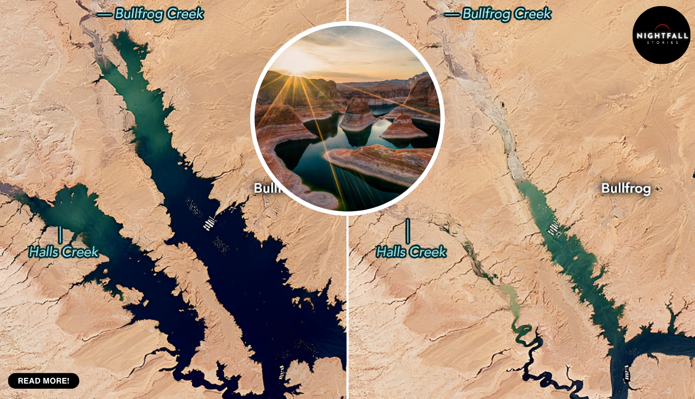
What the satellite record shows is the arithmetic of that imbalance, and it is brutal. Two Landsat images taken nine years apart from the same orbit tell it without a word of commentary. In the earlier frame, dark blue water fills a branching network of bays and flooded side canyons, sprawling through orange desert. In the recent one, taken this month, the same landscape holds what looks less like a lake than a wide river threading a canyon, with the old shoreline standing well back from the water as a pale mineral ring. Glen Canyon Dam and the town of Page sit in the corner of both frames for scale.
Back at the water line, the consequences are less abstract and more expensive.
Bullfrog Marina had been operating on the north side of the lake for decades. As levels fell, its usable ramp retreated to the lowest reach available, and the projections made clear that by midsummer the marina would be aground. The concessionaire’s answer was to relocate the entire facility by barge to deeper water at Halls Crossing on the south side, a job completed earlier this year. A rough temporary ramp extension was opened at Bullfrog to preserve some access, and a permanent replacement ramp at Stanton Creek, budgeted at around 73 million dollars, is intended to allow boats to launch even if the lake falls to 3,500 feet. Once that exists, the marina may be able to come back north.
Read that again, because the detail is easy to skip. A major public works project is being built around the assumption that the reservoir will sit at roughly 3,500 feet. Not as a disaster scenario. As the design elevation.
The people who have been coming here for decades are watching the place they know rearrange itself. One couple has been visiting for the better part of fifty years. Another regular has been coming since the nineteen seventies. They are not tourists passing through; these are families who have measured out summers against the same rock walls, and who now arrive to find the walls considerably taller than they used to be and the water somewhere else entirely. Launch ramps that were open a few seasons ago are closed. Operators who built businesses on water recreation are being pushed to diversify into things that do not require a lake at all.
And the strangest part, the thing several visitors have remarked on, is that the retreat is revealing as much as it removes. Side canyons that have been drowned since the sixties are coming back into the light. Caves, alcoves, arches and rock formations that a generation of boaters knew only as depth readings are now dry ground you can walk on. Glen Canyon is, slowly and involuntarily, reappearing. It is not a comfortable kind of beauty, since the thing exposing it is the failure of the water supply for forty million people, but it is happening, and it complicates any simple reading of what is being lost here.
The scientists who study this system have stopped describing it as a drought that will end. Researchers at the Center for Colorado River Studies at Utah State University, the Oregon Climate Change Research Institute and Arizona State University’s Global Institute of Sustainability and Innovation have all been making a version of the same argument in public for years now: the river was divided up on the basis of an unusually wet stretch of the early twentieth century, the allocations have always exceeded what the river actually delivers in a normal year, and a warming climate is shrinking the supply further. The reservoirs were built to absorb bad years. They have now absorbed more than two decades of them and have very little absorption left.
Which is why the emergency package is best understood as a purchase rather than a solution. What Reclamation bought with Flaming Gorge water and reduced releases is time, measured in months, at the direct cost of Lake Mead’s elevation and Hoover Dam’s output.
Whether the purchase works will be visible by next spring, and it is worth knowing what to watch. The target is at least 3,500 feet by April 2027. Reclamation’s own studies already project the reservoir operating below 3,510 feet during the coming water year, placing it in what the agency calls the Low Elevation Infrastructure Protection Range, which is the bureaucratic term for the zone where keeping the dam functional starts to override other priorities. Two release scenarios for next year were modelled, one at six million acre feet and one at seven, with the final decision due in the annual operating plan. The agency is careful to say that these projections carry significant uncertainty and that real conditions can land outside the modelled range, which in recent years they have done, mostly in the wrong direction.
There is one small, cautious piece of good news buried in the daily numbers. The lake stopped falling. The record low was set in mid August; the reading in early September was 3,517.24 feet, and the most recent reading is 3,517.69 feet. That is a rise of under half a foot, which on a reservoir this size is close to nothing, but the direction of a line matters more than its slope when the line has been heading down for years. The upstream releases are arriving. Whether they arrive fast enough to add the remaining distance to 3,500 feet before next April depends almost entirely on a winter that has not happened yet.
Everything about this system now runs on snow that has not fallen, in mountains several hundred miles upstream, landing on ground that has been getting steadily warmer.
That is the honest state of it. A reservoir at twenty two percent, sitting under its all time record, roughly twenty eight feet above the elevation where the turbines stop working and about 148 feet above the elevation where the dam effectively stops passing water. A federal agency openly moving water between reservoirs to hold a line, and openly accepting damage to the reservoir downstream in order to do it. A marina that had to swim for deeper water, and a new boat ramp being engineered on the assumption that the lake will not come back to where it was.
And underneath all of it, a canyon that was flooded within living memory, coming back into view one bleached rock band at a time, on a timetable nobody chose.